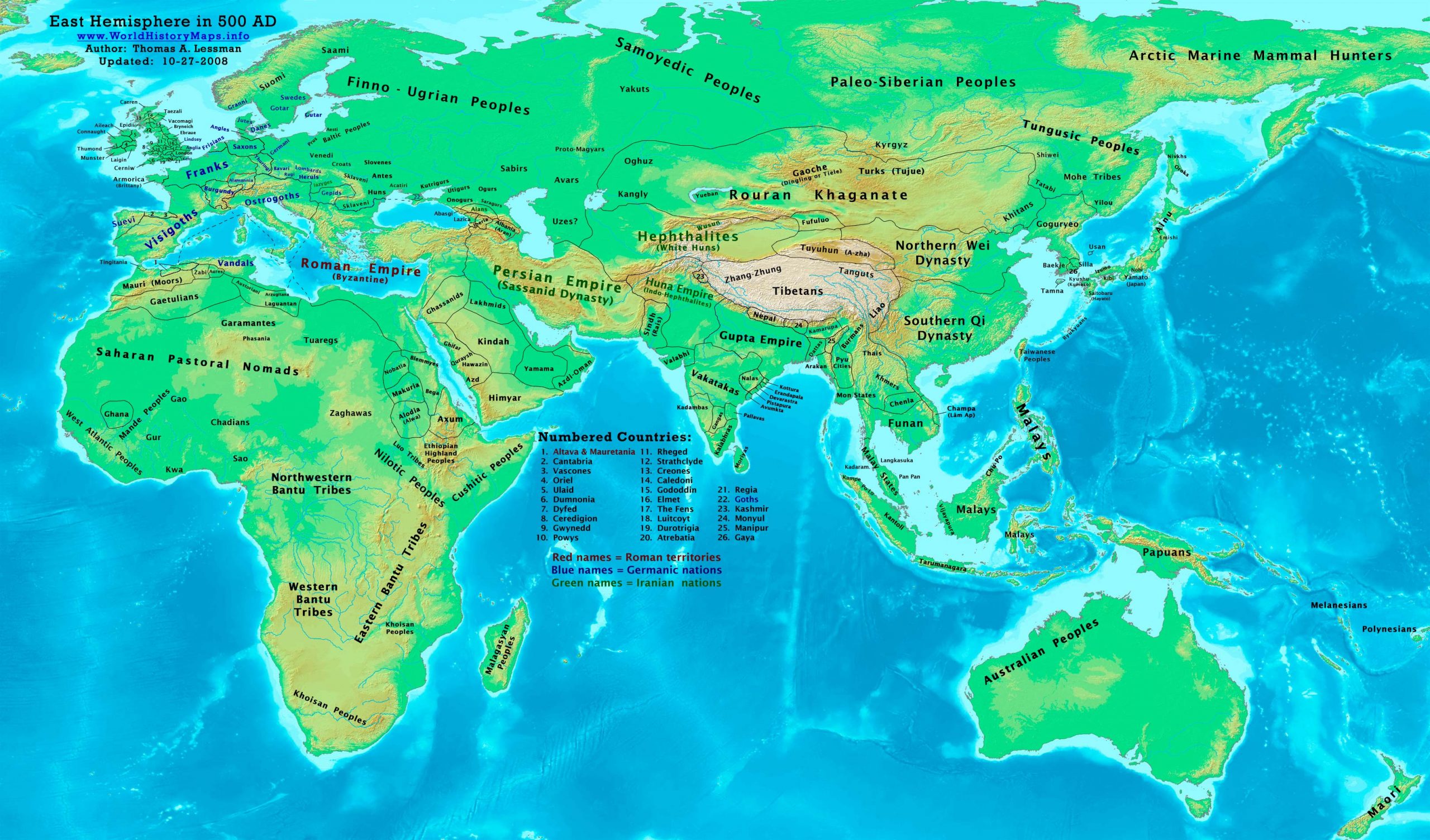
https://www.worldhistorymaps.info/wp-content/uploads/2021/02/map-500ad.jpg
Primary Sources for East-Hem_500ad.jpg:
- The DK Atlas of World History, 2000 edition. Map of “The World in 500 CE”. Pgs 50-51.
- John Nelson. Interactive Historical Atlas of the World since 500BCE. Map of the “Countries of the World 1/1/500 CE.”
World History Maps Inc., Alexandria, VA, 2008. Available at www.WorldHistoryMaps.com.
- Albert Herrmann, Ph.D. History & Commercial Atlas of China. Map of “South Ch’i & North Wei Dynasties in 500 AD”.
Harvard University Press 1935. Available at http://huhai.net.
- Euratlas. Periodical Historical Atlas of Europe. Map of “Europe in 500 AD”.
Euratlas-Nüssli, rue du Milieu 30, 1400 Yverdon-les-Bains, Switzerland
- User:Javierfv1212. Map of “The_world_in_500_CE”. Available on Wikipedia.
- Denis Bellemare. Historical Atlas of Late Antiquity. See specific references below.
- Wikipedia. Various history articles (noted below).
I – African information:
* African Tribal locations are derived from:
- The DK Atlas of World History. Map of “The Development of Complex Societies in Africa”. (Pg 160).
(Bantus, Berber Tribes, Chadians, Cushites, Daamat, Garamantes, Gur, Khoisan Peoples, Kwa, Libyans, Mandes,
Nilotic Peoples, West Atlantic Peoples, etc.)
* North African borders are derived from a combination of:
- Euratlas. Periodical Historical Atlas of Europe. Maps of “Europe in 500 AD” and “Europe in 600 AD”.
* Nubian/Sudanese borders (Makuria, Nobatia, Alodia, Blemmyes, Bega, Axum, etc.):
- The DK Atlas of World History. Map of “Northeast Africa c. 500 CE”. (Pg. 161)
- Denis Bellemare. Historical Atlas of Late Antiquity. Map of “Southern Arabia in 540 AD”
* Ghana’s location and estimated border is from:
- John Nelson. Interactive Historical Atlas of the World since 500BCE. Map of the “Countries of the World 1/1/500 CE.”
- Chow Ka Fat. “A Chronology of World Political History(1-500 CE)”. Reference 3rd century: Berbers found the Kingdom of Ghana.
* North African borders are from a comparison of:
1.Denis Bellemare. Historical Atlas of Late Antiquity. Maps of “Northwest Africa in 500 AD” and “Northeast Africa in 500 AD”.
- John Nelson. Interactive Historical Atlas of the World since 500BCE. Map of the “Countries of the World 1/1/500 CE.”
- Euratlas. Periodical Historical Atlas of Europe. Map of “Europe in 500 AD”.
II – Asian Information
* Arabian borders & Tribal locations:
Note: The information shown in these maps conflicts, even taking the 40-year difference between them.
I used information in various Wikipedia articles to reconcile the sources and depict the locations to the best of my abilities.
- The MidEastWeb.org map of Arabia in 500 CE.
- Denis Bellemare. Historical Atlas of Late Antiquity. Maps of “Southern Arabia in 540 AD” and “North Arabia in 540 AD”.
- User:Slackerlawstudent. Map of “Pre-Islamic Arab tribal locations”. Available on Wikipedia.
* East Asian borders are from:
- Albert Herrmann, Ph.D. History & Commercial Atlas of China. Map of “South Ch’i & North Wei Dynasties in 500 AD”.
* Greater India (Including modern Bangladesh, India, and Pakistan):
- John Nelson. Interactive Historical Atlas of the World since 500BCE. Map of the “Countries of the World 1/1/500 CE.”
- Joseph Schwartzberg. The Historical Atlas of South Asia. Maps of “The Gupta-Vakataka Age, c. A.D. 300-500“
and “The age of Pusyabhuti and Calukyan ascendancy, c. A.D. 550-700“.
* Hephthalite borders are derived from a combination of:
- North borders: History & Commercial Atlas of China. Map of “South Ch’i & North Wei Dynasties in 500 AD”.
- East borders: Interactive Historical Atlas of the World since 500BCE. Map of “Countries of the World 1/1/500 CE”.
* Japanese Islands :
- The DK Atlas of World History. Map of “State Formation in Korea & Japan to 650 CE”; (Pg 264)
* Korean borders:
- Park Hyeon. Map of “History_of_Korea-476. Available on Wikipedia.
* Rouran/Juan-Juan Khaganate:
- John Nelson. Interactive Historical Atlas of the World since 500BCE. Map of the “Countries of the World 1/1/500 CE.”
- Albert Herrmann, Ph.D. History & Commercial Atlas of China. Map of “South Ch’i & North Wei Dynasties in 500 AD”.
* Persian Empire (Sassanid Dynasty):
- Eastern borders are from: John Nelson. Interactive Historical Atlas of the World since 500BCE.
Map of the “Countries of the World 1/1/500 CE.”
- North & West borders are from: Euratlas. Periodical Historical Atlas of Europe. Map of “Europe in 500 AD”.
* Southeast Asia (Indochina, Indonesia, etc.):
- Joseph Schwartzberg. The Historical Atlas of South Asia. Map of “Southeast Asia to c. A.D. 650”. (Pg 30)
- The DK Atlas of World History, 2000 edition. Map of ” Southeast Asia to 650 CE”. (Pg 241)
III – European Information
* European borders are mostly derived from a combination of:
- Euratlas. Periodical Historical Atlas of Europe. Map of “Europe in 500 AD”.
Note: User:Bogomolov.PL has discovered possible discrepancies in my north European borders, compared to the Euratlas maps, due to the differences in the geographical layout of the maps.
- John Nelson. Interactive Historical Atlas of the World since 500BCE. Map of the “Countries of the World 1/1/500 CE.”
World History Maps Inc., Alexandria, VA, 2008. Available at www.WorldHistoryMaps.com.
- Denis Bellemare. Historical Atlas of Late Antiquity. Maps of “West Europe“, “East Europe“, and “North Europe” in 500 AD”
* British Isles & Ireland (Anglo-Saxons, Celts, Romano-Celts, etc.) are derived from:
- David Nash Ford. Early British Kingdoms. Map of “Britain in 500 AD”.
- User:Briangotts’. Map of “Britain_500_CE”. Available on Wikipedia.
Note: Much of the information in this map was cross-checked with Regnal Chronologies by Bruce Gordon.
Year 500 (D) was a leap year starting on Saturday of the Julian calendar. At the time, it was known as the Year of the Consulship of Patricius and Hypatius. The denomination 500 for this year has been used since the early medieval period, when the Anno Domini calendar era became the prevalent method in Europe for naming years. The year 500 is considered the beginning of the Middle Ages, approximately.
Source: Wikipedia