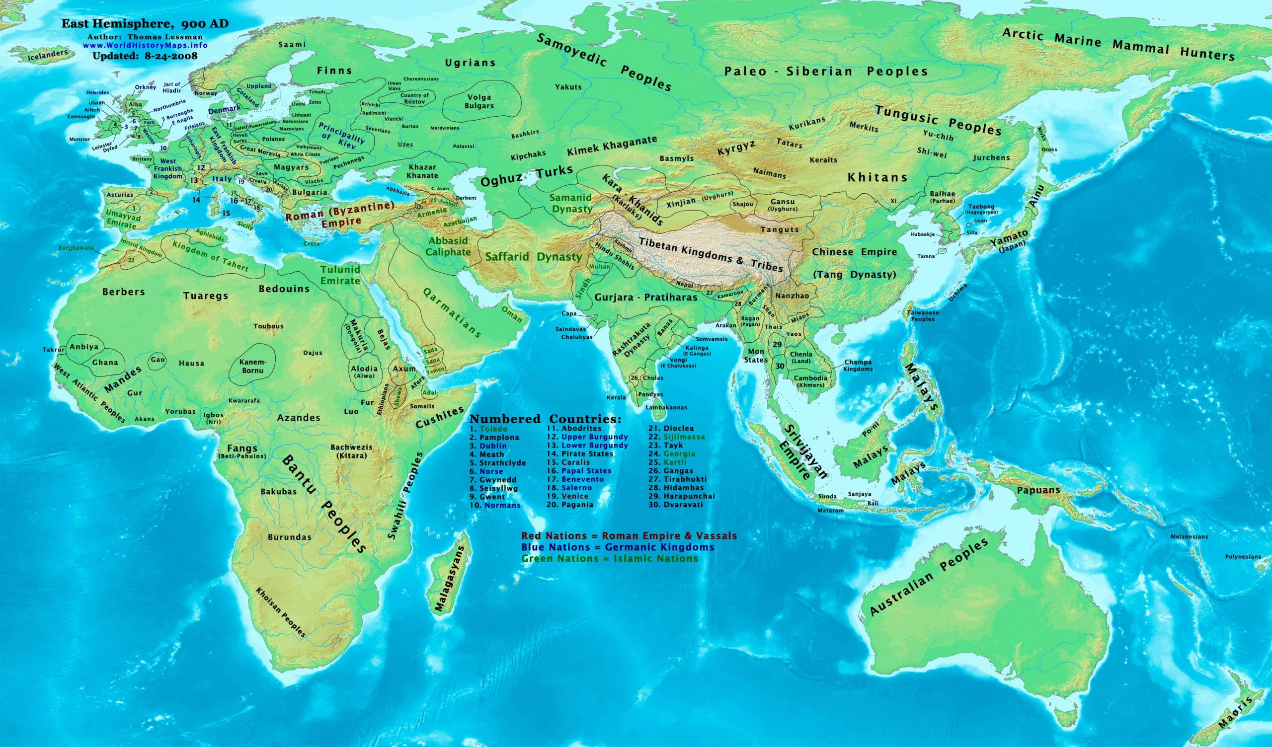
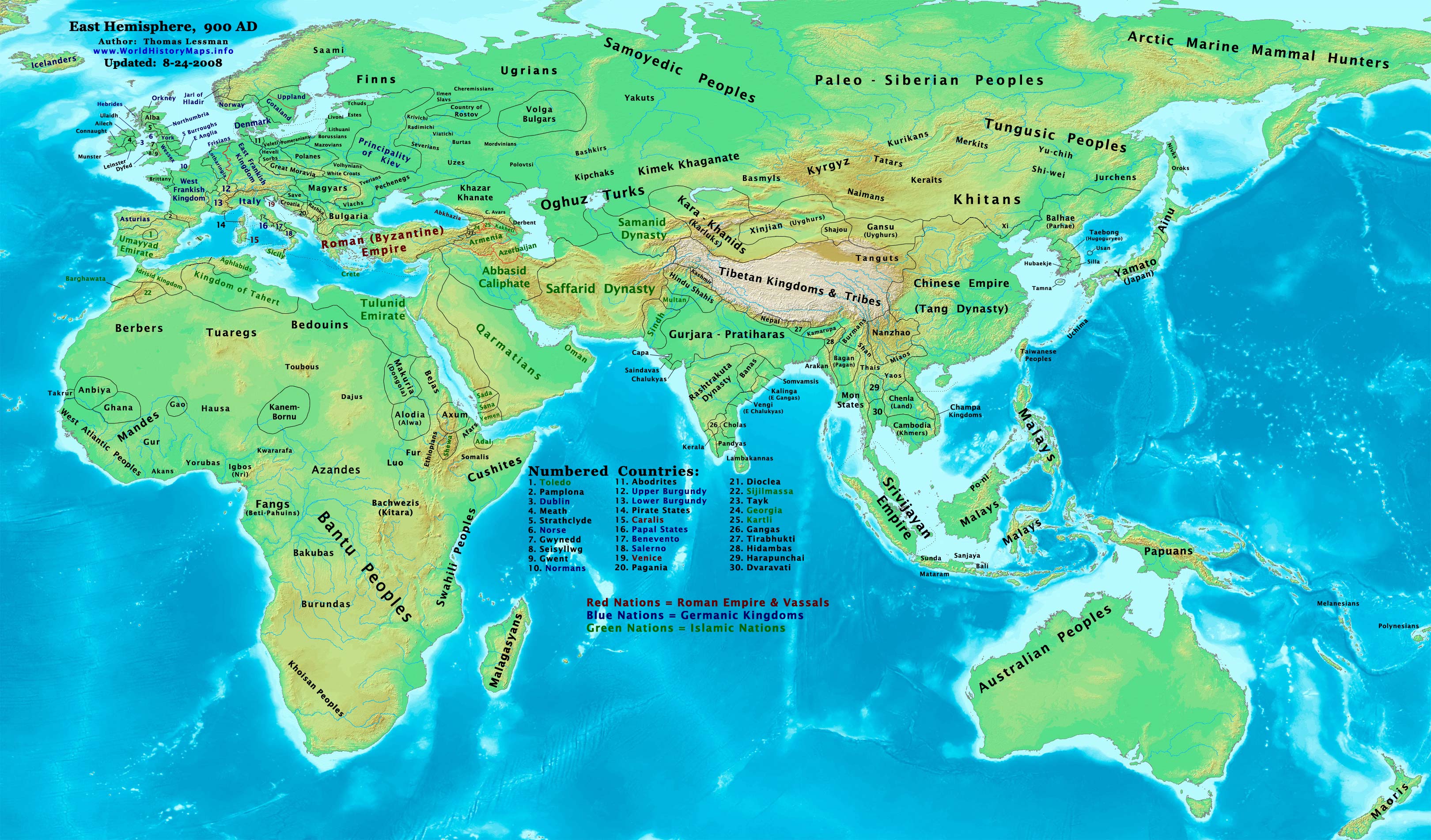
https://www.worldhistorymaps.info/wp-content/uploads/2021/02/map-900ad.jpg
Primary Sources for East-Hem_900ad.jpg:
- The DK Atlas of World History, 2000 edition.
- John Nelson. Interactive Historical Atlas of the World since 500BCE. Map of the “Countries of the World 1/1/900 CE.”
World History Maps Inc., Alexandria, VA, 2008. Available at www.WorldHistoryMaps.com.
- Euratlas. Periodical Historical Atlas of Europe. Map of “Europe in 900 AD”.
- Joseph Schwartzberg. The Historical Atlas of South Asia.
- User:Javierfv1212. Map of “World_Map_900_CE.PNG”. Available on Wikipedia.
I – African information
* African Tribal locations are derived from:
- The DK Atlas of World History, 2000 Edition. Combination of:
a – Maps of “Islam & New States in Africa”. Pgs 162-163.
b – Map of “The Development of Complex Societies in Africa ”. Pg 160.
c – Map of “The World in 750 CE”. Pgs 54-55.
d – Map of “The World in 1000 CE”. Pgs 58-59.
- User:Javierfv1212. Map of “World_Map_900_CE.PNG”. Available on Wikipedia.
- Wikipedia. Articles related to peoples and states depicted in the map.
* Ghana , Anbiya, & Gao are derived from:
- The DK Atlas of World History, 2000 Edition. Map of “The World in 750 CE”. Pgs 54-55.
* North African borders are derived from:
- Euratlas. Periodical Historical Atlas of Europe. Map of “Europe in 900 AD”.
- John Nelson. Interactive Historical Atlas of the World since 500BCE. Map of the “Countries of the World 1/1/900 CE.”
II – Asian Information
* Arab Empire (Abbasid Caliphate) borders are derived from:
- John Nelson. Interactive Historical Atlas of the World since 500BCE. Map of the “Countries of the World 1/1/900 CE.”
- Euratlas. Periodical Historical Atlas of Europe. Map of “Europe in 900 AD”.
* Central Asia & Steppe Tribes are derived from:
- Albert Herrmann, Ph.D. History & Commercial Atlas of China. Map of “Manchuria under Liao Dynasty, 937-1125 AD”.
- The DK Atlas of World History, 2000 Edition. Map of “The World in 750 CE”. Pgs 54-55.
* Chinese Empire (Tang Dynasty) borders are from:
- John Nelson. Interactive Historical Atlas of the World since 500BCE. Map of the “Countries of the World 1/1/900 CE.”
- Albert Herrmann, Ph.D. History & Commercial Atlas of China. Map of “The Five Dynasties, 907-960 AD”.
* Greater India (Including modern Bangladesh, India, and Pakistan):
- John Nelson. Interactive Historical Atlas of the World since 500 BCE . Map of the “Countries of the World 1/1/900 CE.”
- Joseph Schwartzberg. The Historical Atlas of South Asia. Combination of:
a – Map of “The Age of Gurjara-Pratiharas, Palas, & Rastrakutas, c. A.D. 700-975“.
b – Map of “Islamic Expansion & Western views of SE Asia, 7th-12th centuries”.
* Japanese Islands information is from:
- John Nelson. Interactive Historical Atlas of the World since 500BCE. Map of the “Countries of the World 1/1/900 CE.”
- The DK Atlas of World History, 2000 Edition. Map of “The First Empires of Japan ”. Pg 264.
* Khazar Khanate borders:
- Euratlas. Periodical Historical Atlas of Europe. Map of “Europe in 900 AD”.
- John Nelson. Interactive Historical Atlas of the World since 500BCE. Map of the “Countries of the World 1/1/900 CE.”
* Korean & Manchurian information:
Note: My two sources for Korea in 900 AD (listed here) conflict with each other and show different information. Upon
studying both sources, along with additional information from Wikipedia, I decided to go with the borders depicted.
- Park Hyeon. Historical Maps of Korea. Map of “Korea in 901 AD”. Available on Wikipedia.
- John Nelson. Interactive Historical Atlas of the World since 500BCE. Map of the “Countries of the World 1/1/900 CE.”
- Wikipedia. Articles about the “Later Three Kingdoms” of “Hubaekje” and “Taebong”.
* Roman (Byzantine) Empire borders:
- Euratlas. Periodical Historical Atlas of Europe. Map of “Europe in 900 AD”.
- John Nelson. Interactive Historical Atlas of the World since 500BCE. Map of the “Countries of the World 1/1/900 CE.”
* Southeast Asia (including Champa, Chenla, Dvaravati, Nanzhao, Pyu, modern Indonesia, etc.):
- The DK Atlas of World History, 2000 edition. Map of “Southeast Asia, 650-1250 CE”. Pg 245.
- Joseph Schwartzberg. The Historical Atlas of South Asia. Map of “Southeast Asia, C. 650-1250 AD”.
- John Nelson. Interactive Historical Atlas of the World since 500BCE. Map of the “Countries of the World 1/1/900 CE.”
III – European Information
* European information is derived primarily from:
- Euratlas. Periodical Historical Atlas of Europe. Map of “Europe in 900 AD”.
Note: User:Bogomolov.PL has discovered possible errors in some of my European borders
compared to this source, due to the different geographical layout of the maps.
* Roman (Byzantine) Empire borders:
- Euratlas. Periodical Historical Atlas of Europe. Map of “Europe in 900 AD”.
- John Nelson. Interactive Historical Atlas of the World since 500BCE. Map of the “Countries of the World 1/1/900 CE.”
Note: Much of the information in this map was cross-checked with Bruce Gordon’s Regnal Chronologies
- Fringe areas likeAfrica, Australia , Siberia , etc. derive from Wikipedia World Map in 900 CE, created by User:Javierfv1212.
907 AD Five Dynasties Begin- The period between 907-959 was known as the period of Five Dynsties. During this period imperial control was largely limited to the Yellow River Basin.
Source: historycentral.com