
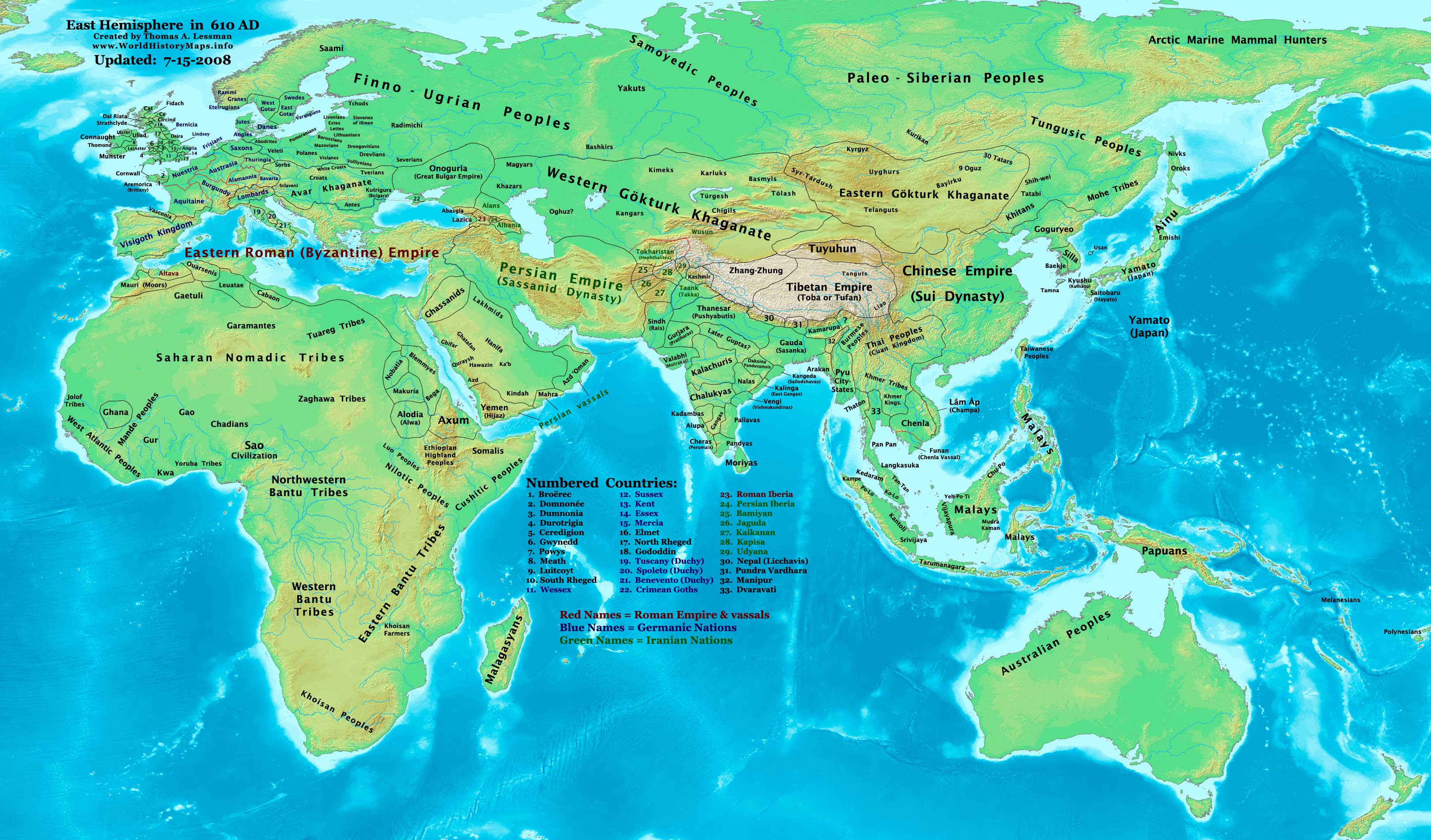
https://www.worldhistorymaps.info/wp-content/uploads/2021/02/map-610ad.jpg
Primary Sources for East-Hem_610ad.jpg:
- The DK Atlas of World History, 2000 edition. (See specific references below)
- John Nelson. Interactive Historical Atlas of the World since 500BCE. Map of the “Countries of the World 1/1/610CE.”
World History Maps Inc., Alexandria, VA, 2008. Available at www.WorldHistoryMaps.com.
- Albert Herrmann, Ph.D. History & Commercial Atlas of China. Map of “Asia in 610 AD”.
Harvard University Press 1935. Available at http://huhai.net.
- Euratlas. Periodical Historical Atlas of Europe. Map of “Europe in 600 AD”.
Euratlas-Nüssli, rue du Milieu 30, 1400 Yverdon-les-Bains, Switzerland
I – African information:
* African Tribal locations are derived from:
- The DK Atlas of World History. Map of “The Development of Complex Societies in Africa”. Pg 160.
(Bantus, Berber Tribes, Chadians, Cushites, Daamat, Garamantes, Gur, Khoisan Peoples, Kwa, Libyans, Mandes,
Nilotic Peoples, West Atlantic Peoples, etc.)
* North African borders are derived from a combination of:
- Euratlas. Periodical Historical Atlas of Europe. Map of “Europe in 600 AD”.
- Dennis Bellemare. Historical Atlas of Late Antiquity. Map of “North Africa in 580 AD”.
II – Asian information:
* Chinese Empire (Tang Dynasty) borders are derived from:
- Albert Herrmann, Ph.D. History & Commercial Atlas of China. Map of “The Sui Dynasty, 581-618 A.D.”
* Gökturk Khaganates (Eastern & Western) derive from:
- Albert Herrmann, Ph.D. History & Commercial Atlas of China. Map of “Asia in 610 AD”.
- John Nelson. Interactive Historical Atlas of the World since 500BCE. Map of the “Countries of the World 1/1/600CE.”
- User:Briangotts. Map of “Gökturk Khaganates, c. 600 CE”. Available on Wikipedia.
Note: My map shows the Western Gökturk borders extended further north and west than depicted
in the first two source maps above. The reason is described in the Wikipedia’s article about the Gökturks
(and other sources), which describes Gökturk campaigns to the Black sea in 567 and 576 AD, and a
Caucasian campaign during the 3rd Perso-Turkic war (627-629 AD).
* Indian Kingdoms and borders are derived from a combination of:
- John Nelson. Interactive Historical Atlas of the World since 500BCE. Map of the “Countries of the World 1/1/610CE.”
- Joseph Schwartzberg. The Historical Atlas of South Asia. Map of “Age of Pusyabhutis & Calukyans, A.D. 550-700”. Pg 26.
* Japanese Islands :
- The DK Atlas of World History. Map of “State Formation in Korea & Japan to 650 CE”; (Pg 264)
* Korean Borders are derived a combination of:
- Albert Herrmann, Ph.D. History & Commercial Atlas of China. Map of “Asia in 610 AD”
- Park Hyeon. (Wikipedia User:Historiographer). Maps of “Korea in 576” and “Korea in 646”.
* Persian Empire (Sassanid Dynasty) borders are derived from:
- Eastern borders are from: Albert Herrmann, Ph.D. History & Commercial Atlas of China. Map of “Asia in 610 AD”
- Western borders are from: Euratlas. Periodical Historical Atlas of Europe. Map of “Europe in 600 AD”.
* Southeast Asian kingdoms are derived from a combination of:
- Joseph Schwartzberg. The Historical Atlas of South Asia. Map of “Southeast Asia to c. A.D. 650”. Pg 30.
- The DK Atlas of World History, 2000 edition. Map of ” Southeast Asia to 650 CE”. Pg 241.
* Tibetan Empire borders are partially derived from
- John Nelson. Interactive Historical Atlas of the World since 500BCE. Map of the “Countries of the World 1/1/610 CE.”
III – European information:
* European borders are mostly derived from:
- Euratlas. Periodical Historical Atlas of Europe. Map of “Europe in 600 AD”.
- John Nelson. Interactive Historical Atlas of the World since 500BCE. Map of the “Countries of the World 1/1/610 CE.”
Note: User:Bogomolov.PL has discovered possible errors in some of my European borders
compared to this source, due to the different geographical layout of the maps.
* Avar Khaganate borders are derived from a combination of:
- John Nelson. Interactive Historical Atlas of the World since 500BCE. Map of the “Countries of the World 1/1/610 CE.”
- Albert Herrmann, Ph.D. History & Commercial Atlas of China. Map of “Asia in 610 AD”
- Euratlas. Periodical Historical Atlas of Europe. Map of “Europe in 600 AD”.
* British Isles & Ireland (Anglo-Saxons, Celts, Romano-Celts, etc.) are derived from:
- David Nash Ford. Early British Kingdoms. Map of “Britain in 600 AD”.
- Euratlas. Periodical Historical Atlas of Europe. Map of “Europe in 600 AD”.
Note: Much of the information in this map was cross-checked with Bruce Gordon’s Regnal Chronologies.
In 610 CE, Muhammad began receiving what Muslims consider to be divine revelations. Muhammad’s message won over a handful of followers and was met with increasing opposition from Meccan notables.
Source: idesign.wiki