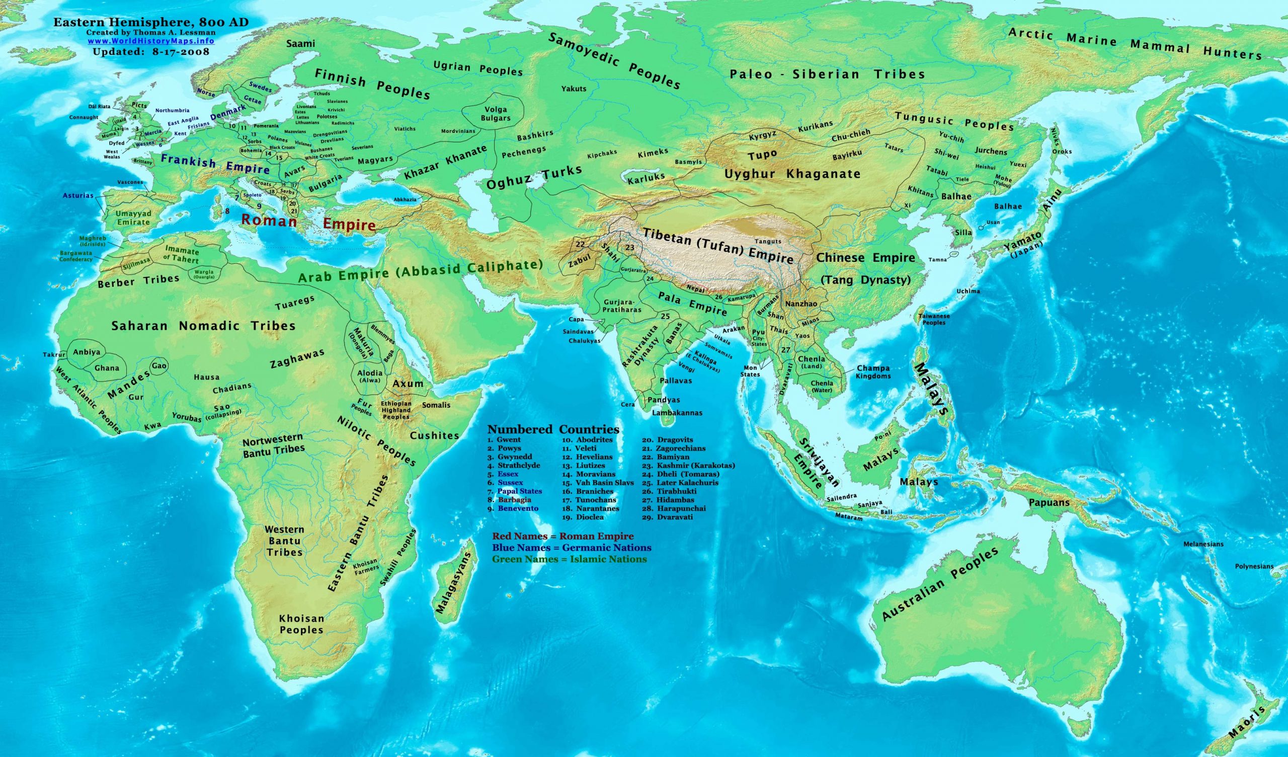
https://www.worldhistorymaps.info/wp-content/uploads/2021/02/map-800ad.jpg
Primary Sources for East-Hem_800ad.jpg:
- The DK Atlas of World History, 2000 edition. Map of “The World in 750 CE”. Pgs 54-55.
- John Nelson. Interactive Historical Atlas of the World since 500BCE. Map of the “Countries of the World 1/1/800 CE.”
World History Maps Inc., Alexandria, VA, 2008. Available at www.WorldHistoryMaps.com.
- Euratlas. Periodical Historical Atlas of Europe. Map of “Europe in 800 AD”.
- Wikipedia. Several various articles and a combination of these two maps:
a – User:Javierfv1212. Map of “The_world_in_750_CE”.
b – User:Briangotts. Map of the “World_820.png”.
I – African information
* African Tribal locations are derived from:
- The DK Atlas of World History, 2000 Edition. Combination of:
a – Map of “The World in 750 CE”. Pgs 54-55.
b – Map of “The Development of Complex Societies in Africa ”. Pg 160.
- User:Javierfv1212. Map of “The_world_in_750_CE”. Available on Wikipedia.
* Ghana , Anbiya, & Gao are derived from:
- The DK Atlas of World History, 2000 Edition. Map of “The World in 750 CE”. Pgs 54-55.
* North African borders are derived from:
- Euratlas. Periodical Historical Atlas of Europe. Map of “Europe in 800 AD”.
- John Nelson. Interactive Historical Atlas of the World since 500BCE. Map of the “Countries of the World 1/1/800 CE.”
* Sao Civilization (collapsing) is derived from:
- Wikipedia. Article about the “Sao Civilization”.
II – Asian Information
* Asian information is derived primarily from these sources:
- The DK Atlas of World History, 2000 Edition. Map of “The World in 750 CE”. Pgs 54-55.
- Albert Herrmann, Ph.D. History & Commercial Atlas of China. Map of “Asia in 750 AD”.
- John Nelson. Interactive Historical Atlas of the World since 500BCE. Map of the “Countries of the World 1/1/800 CE.”
- User:Javierfv1212. Map of “World_Map_700_CE.PNG”. Available on Wikipedia.
* Arab Empire (Abbasid Caliphate) borders are derived from:
- John Nelson. Interactive Historical Atlas of the World since 500BCE. Map of the “Countries of the World 1/1/800 CE.”
- Euratlas. Periodical Historical Atlas of Europe. Map of “Europe in 800 AD”.
* Central Asia & Steppe Tribes are derived from:
- Albert Herrmann, Ph.D. History & Commercial Atlas of China. Map of “Asia in 750 AD”.
- The DK Atlas of World History, 2000 Edition. Map of “The World in 750 CE”. Pgs 54-55.
* Chinese Empire (Tang Dynasty) borders are from:
- John Nelson. Interactive Historical Atlas of the World since 500BCE. Map of the “Countries of the World 1/1/800 CE.”
* Greater India (Including modern Bangladesh, India, and Pakistan):
- John Nelson. Interactive Historical Atlas of the World since 500 BCE . Map of the “Countries of the World 1/1/800 CE.”
- Joseph Schwartzberg. The Historical Atlas of South Asia. Combination of:
a – Map of “The Age of Gurjara-Pratiharas, Palas, & Rastrakutas, c. A.D. 700-975“.
b – Map of “Islamic Expansion & Western views of SE Asia, 7th-12th centuries”.
* Japanese Islands information is from:
- John Nelson. Interactive Historical Atlas of the World since 500BCE. Map of the “Countries of the World 1/1/800 CE.”
- The DK Atlas of World History, 2000 Edition. Map of “The First Empires of Japan ”. Pg 264.
* Khazar Khanate borders:
- Euratlas. Periodical Historical Atlas of Europe. Map of “Europe in 800 AD”.
- John Nelson. Interactive Historical Atlas of the World since 500BCE. Map of the “Countries of the World 1/1/800 CE.”
* Korean & Manchurian information:
- Park Hyeon. Historical Maps of Korea. Maps of “Korea in 732 AD” and “Korea in 830 AD”. Available on Wikipedia.
* Roman (Byzantine) Empire borders:
- Euratlas. Periodical Historical Atlas of Europe. Map of “Europe in 800 AD”.
- John Nelson. Interactive Historical Atlas of the World since 500BCE. Map of the “Countries of the World 1/1/800 CE.”
* Southeast Asia (including Champa, Chenla, Dvaravati, Nanzhao, Pyu, modern Indonesia, etc.):
- The DK Atlas of World History, 2000 edition. Map of “Southeast Asia, 650-1250 CE”. Pg 245.
- Joseph Schwartzberg. The Historical Atlas of South Asia. Map of “Southeast Asia, C. 650-1250 AD”.
- John Nelson. Interactive Historical Atlas of the World since 500BCE. Map of the “Countries of the World 1/1/800 CE.”
* Tibetan Empire borders are derived from a combination of:
Note: User:Porikolpok_Oxom created this map of “Kamarupa_7th-8th_Century_AD.jpg”, which depicts different borders
for Kamarupa, Gauda, Tripura, and Manipur.
- The DK Atlas of World History, 2000 edition. Map of “Tang China & its neighbors c. 750 CE”. Pg 262.
Note: The DK Atlas depicts Tibet ’s borders (c. 800 AD) including northern India for the entire length of
the Ganges river, including Kamarupa, Bengal , Magadha , etc., under control of Tibet .
- Albert Herrmann, Ph.D. History & Commercial Atlas of China. Map of “Asia in 750 AD”.
Note: Herrmann’s map depicts Tibetan control over Kamarupa, Bengal, and Pala in 750 AD
- John Nelson. Interactive Historical Atlas of the World since 500BCE. Map of the “Countries of the World 1/1/700 CE.”
Note: Nelson’s map depicts Tibetan control only over the Tibetan plateau region.
- Joseph Schwartzberg. The Historical Atlas of South Asia. Map of “Pusyabhuti & Calukyan ascendancy c. 550-700 AD“.
Note: Map notes that Tibetan King Songtsän Gampo (582?-650 AD) conquered Nepal and Kamarupa, and invaded Tirabhukti.
- Alex McKay. “The History of Tibet: Vol 1, Early Period to 850 AD”. Pg 54. (ISBN:0415308429)
Note: States that Nepal ’s Licchavi Dynasty became vassals of Tibet in the early 600s AD. Also notes the Pala Empire
under King Dharmapala accepted Tibetan overlordship.
- S. Chand. “Ancient India”. Pg 632. Available through Google books. (ISBN:8121908876)
Note: Describes Tibetan activities in India during the reign of King Songtsän Gampo of Tibet and King Harsha Vardhana
of Kannauj. Also describes Tibetan sovereignty over Kamarupa and Kannauj after the death of King Harsha.
- Wikipedia. Articles about “History of Tibet” and “Songtsän Gampo”.
Note: The articles state that Tibet & Nepal led a joint attack on Harsha’s successor in 648 AD, and subjugated
northern India in retaliation for an Indian attack on a Chinese envoy named Xuanzang.
- RA Stein. “Tibetan Civilization”. (Revised English edition, 1972). Stanford University Press, Pg 62.
(ISBN 0-8047-0806-1 cloth; ISBN 0-8047-0901-7 pbk., pp. 58-59)
- New York : The Metropolitan Museum of Art, Oct 2001. Timeline of Art History.
Section on the “Himalayan Region, 500-1000 AD”.
* Uyghur Khaganate information is derived from:
- John Nelson. Interactive Historical Atlas of the World since 500BCE. Map of the “Countries of the World 1/1/800 CE.”
III – European Information
* European information is derived primarily from:
- Euratlas. Periodical Historical Atlas of Europe. Map of “Europe in 800 AD”.
Note: User:Bogomolov.PL has discovered possible errors in some of my European borders
compared to this source, due to the different geographical layout of the maps.
- John Nelson. Interactive Historical Atlas of the World since 500BCE. Map of the “Countries of the World 1/1/800 CE.”
Note: Much of the information in this map was cross-checked with Bruce Gordon’s Regnal Chronologies.
800 AD Charlemagne- Emperor Of The West- Charlemagne was crowned Emperor of the West by Pope Leo III on December 25th — Christmas Day — in St. Peters Church. Pope Leo allowed Charlemagne to clear himself of a series of charges. The coronation of Charlemagne represented an irrevocable breach between Constantinople and Rome.
Source: historycentral.com