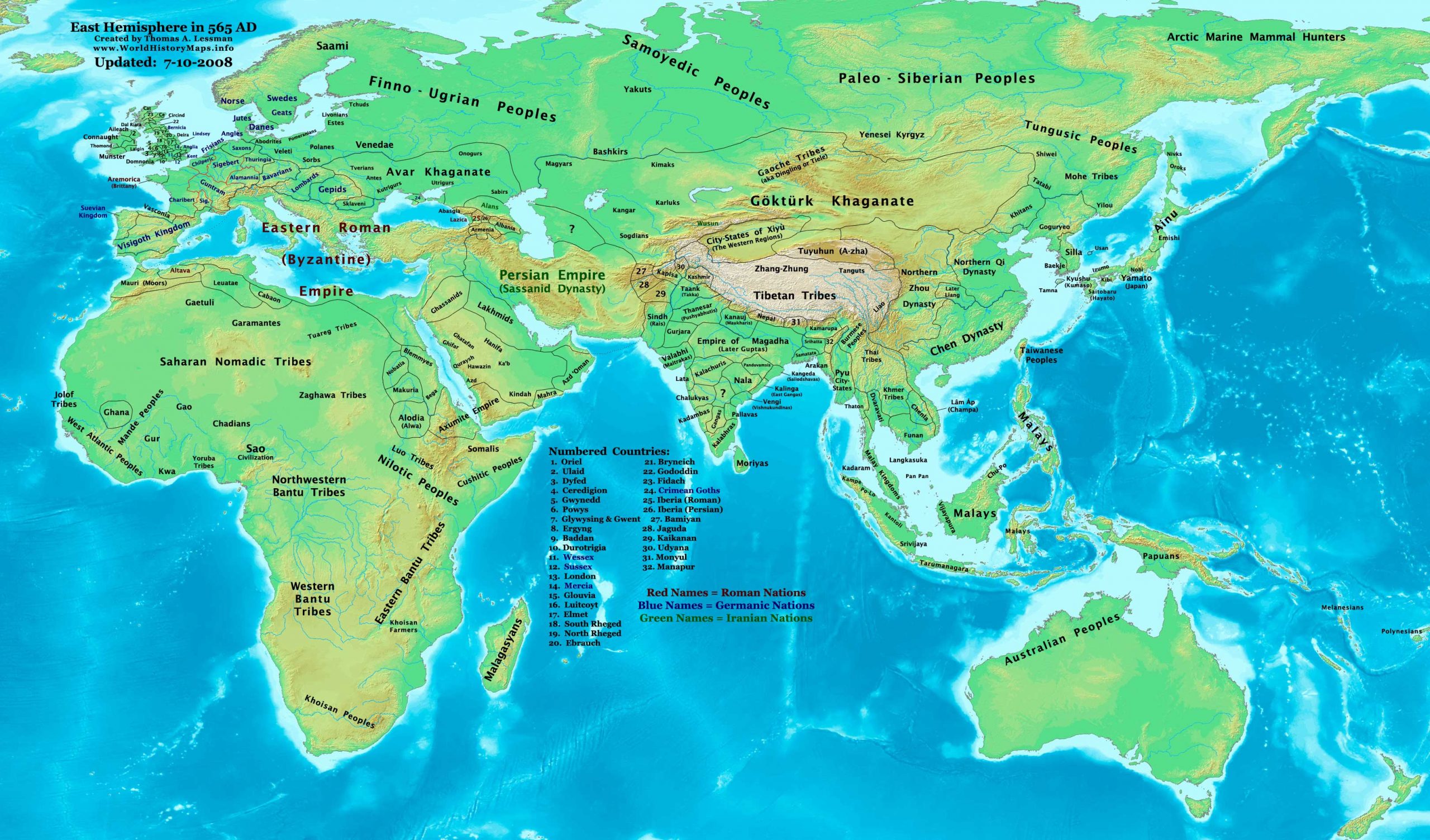
https://www.worldhistorymaps.info/wp-content/uploads/2021/02/map-565ad.jpg
Primary Sources for East-Hem_565ad.jpg:
- The DK Atlas of World History, 2000 edition. Map of “The World in 500 CE”, (Pg 50-51)
(More specific DK references below)
- John Nelson. Interactive Historical Atlas of the World since 500BCE. Map of the “Countries of the World 1/1/565 CE.”
World History Maps Inc., Alexandria, VA, 2008. Available at www.WorldHistoryMaps.com.
- Albert Herrmann, Ph.D. History & Commercial Atlas of China. Maps of “The Divisions of China, 560 AD” and “Asia in 610 AD”.
Harvard University Press 1935. Available at http://huhai.net.
- Euratlas. Periodical Historical Atlas of Europe. Maps of “Europe in 500 AD” and “Europe in 600 AD”.
Euratlas-Nüssli, rue du Milieu 30, 1400 Yverdon-les-Bains, Switzerland
- User:Javierfv1212. Map of “The_world_in_500_CE”. Available on Wikipedia.
- Wikipedia. Various history articles (noted below).
I – African information:
* African Tribal locations are derived from:
- The DK Atlas of World History. Map of “The Development of Complex Societies in Africa”. (Pg 160).
(Bantus, Berber Tribes, Chadians, Cushites, Daamat, Garamantes, Gur, Khoisan Peoples, Kwa, Libyans, Mandes,
Nilotic Peoples, West Atlantic Peoples, etc.)
* North African borders are derived from a combination of:
- Euratlas. Periodical Historical Atlas of Europe. Maps of “Europe in 500 AD” and “Europe in 600 AD”.
* Nubian/Sudanese borders (Makuria, Nobatia, Alodia, Blemmyes, Bega, Axum, etc.):
- The DK Atlas of World History. Map of “Northeast Africa c. 500 CE”. (Pg. 161)
- Denis Bellemare. Historical Atlas of Late Antiquity. Map of “Southern Arabia in 540 AD”
* Ghana’s location and estimated border is from:
- John Nelson. “Countries of the World 1/1/565 CE.” (See #2 under Primary Sources)
* North African borders are from a comparison of:
- Denis Bellemare. Historical Atlas of Late Antiquity. Comparison of “North Africa in 540 AD” and “North Africa in 580 AD”.
- John Nelson. “Countries of the World in 1/1/565 CE.” (see #2 under Primary Sources)
- Euratlas. Periodical Historical Atlas of Europe. Map of “Europe in 600 AD”.
II – Asian Information
* Arabian borders & Tribal locations:
Note: The information shown in these maps conflicts, even taking the 40-year difference between them.
I used information in various Wikipedia articles to reconcile the sources and depict the locations to the best of my abilities.
- TheMidEastWeb.org map of Arabia in 500 CE.
- Denis Bellemare. Historical Atlas of Late Antiquity. Maps of “Southern Arabia in 540 AD” and “North Arabia in 540 AD”.
- User:Slackerlawstudent. Map of “Pre-Islamic Arab tribal locations”. Available on Wikipedia.
* East Asian borders (Chen, Northern Zhou, Northern Qi, etc.) are from:
- Albert Herrmann, Ph.D. History & Commercial Atlas of China. Map of “The Divisions of China, 530 & 560 AD”.
* Greater India (Including modern Bangladesh, India, and Pakistan):
- John Nelson. Interactive Historical Atlas of the World since 500 BCE . Map of the “Countries of the World 1/1/565 CE.”
World History Maps Inc., Alexandria, VA, 2008. Available at www.WorldHistoryMaps.com.
- Joseph Schwartzberg. The Historical Atlas of South Asia. Maps of “The Gupta-Vakataka Age, c. A.D. 300-500“
and “The age of Pusyabhuti and Calukyan ascendancy, c. A.D. 550-700“.
* Japanese Islands :
- The DK Atlas of World History. Map of “State Formation in Korea & Japan to 650 CE”; (Pg 264)
* Korean borders are derived from:
- Park Hyeon. Map of “History of Korea-576”. Available on Wikipedia.
* Persian Empire (Sassanid Dynasty):
- John Nelson. Interactive Historical Atlas of the World since 500 BCE . Map of the “Countries of the World 1/1/565 CE.”
World History Maps Inc., Alexandria, VA, 2008. Available at www.WorldHistoryMaps.com.
* Southeast Asia (Indochina, Indonesia, etc.):
- Joseph Schwartzberg. The Historical Atlas of South Asia. Map of “Southeast Asia to c. A.D. 650”. (Pg 30)
- The DK Atlas of World History, 2000 edition. Map of ” Southeast Asia to 650 CE”. (Pg 241)
III – European Information
* European borders are mostly derived from a combination of:
- Euratlas. Map of “Europe in 600 AD” (and to a lesser extent, their map of “Europe in 500 AD”).
Note: User:Bogomolov.PL has discovered possible discrepancies in my north European borders,
compared to the Euratlas maps, due to the differences in the geographical layout of the maps.
- John Nelson. Interactive Historical Atlas of the World since 500 BCE . Map of the “Countries of the World 1/1/565 CE.”
World History Maps Inc., Alexandria, VA, 2008. Available at www.WorldHistoryMaps.com.
Note: My map shows Avar borders extender further west. My border is partially derived from Wikipedia’s
article “Eurasian Avars: Arrival in Europe”, which says the Avars reached the Baltic Sea after 559 AD, then
battled the Franks unsuccessfully in Thuringia, before they invaded the Gepid kingdom.
* British Isles & Ireland (Anglo-Saxons, Celts, Romano-Celts, etc.) are derived from:
- David Nash Ford. Early British Kingdoms. Maps of “Britain in 550 AD” and “Britain in 575 AD”.
IV – Australian Information
- The DK Atlas of World History. 2000 edition. Map of “The World in 500 CE”. (Pg 50-51).
- User:Javierfv1212. Map of “The_world_in_500_CE”. Available on Wikipedia.
Note: Much of the information in this map was cross-checked with Bruce Gordon’s Regnal Chronologies.
Jan 22 Eutychius is deposed as Patriarch of Constantinople by John Scholasticus
Aug 22 St Columba reports seeing monster in Loch Ness