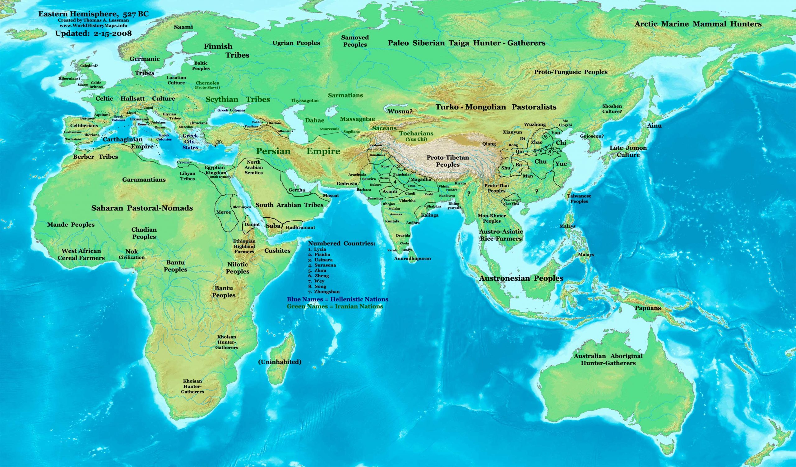
https://www.worldhistorymaps.info/wp-content/uploads/2021/03/map-527bc.jpg
Primary Sources for East-Hem_527bc.jpg:
- The DK Atlas of World History. 2000 edition. Map of “The World in 500 BCE ”. Pgs 34-35.
- The New Penguin Atlas of Ancient History, 2002 edition. Map of “The Near East in 515 BC ”. (Pg 61)
- User:Briangotts. Map of the “World_500_BCE.png”. Available on Wikipedia.
I – African information:
* African Tribal locations are derived from:
- The DK Atlas of World History. Map of “The Development of Complex Societies in Africa”. Pg 160.
(Bantus, Berbers, Chadians, Cushites, Daamat, Garamantes, Gur, Khoisans, Kwa, Libyans, Mandes,
Nilotic Peoples, West Atlantic Peoples, etc.)
- User:Briangotts. Map of the “World_500_BCE.png”. Available on Wikipedia.
* Carthage borders are derived from:
- The DK Atlas of World History. Map of “The Berbers & the Roman Empire”. Pg 161. (Shows Carthage in 500 BCE ).
* Persian Egypt borders:
- The DK Atlas of World History. Map of “The Achaemenid Empire c. 550-331 BCE ”. Pg 223.
II – Asian information:
Note: Much of my Asian peoples and tribal locations are derived from:
- The DK Atlas of World History. Map of “The World in 500 BCE ”. Pgs 34-35.
(Ainu, Dravidians, Finno-Ugrians, Korean Peoples, Malay Peoples, Mon-Khmer Peoples, Palaeosiberians,
Papuans, Saba, Samoyed Peoples, Scythian Tribes, Tochari/Yuezhi, Tungus)
- User:Briangotts. Map of the “World_500_BCE.png”. Available on Wikipedia.
(Ainu, Final Jomon Culture, Korean Peoples, Massagetae, Sakae)
* East Asian ( China ) information:
- The DK Atlas of World History. Map of “Zhou China 1027 – 403 BCE ”. Pg 259.
- Albert Herrmann, Ph.D. History & Commercial Atlas of China. Map of “Chun-ch’iu Period, 722-482 BC”.
* Korean & Manchurian information:
- Park Hyeon. Map of “History_of_Korea_500_BC.png”. Available on Wikipedia.
* Gerrha borders are derived from:
* Greater India (Including modern Bangladesh, India, and Pakistan):
- The DK Atlas of World History. Map of “The World in 500 BCE ”. Pg 35.
- User:Briangotts. Map of the “World_500_BCE.png”. Available on Wikipedia.
- Wikipedia. Map of “Epic India”.
- Pennsylvania University. Map of “Republics & Kingdoms of Northern India, c. 600 BCE”.
* Persian Empire (Achaemenid Dynasty) borders:
- The DK Atlas of World History. Map of “The Achaemenid Empire c. 550-331 BCE ”. Pg 223.
- Livius.org. Map of “Persia in 490 BCE” and article about the “Achaemenians”.
* Văn Lang borders are derived from:
- User:Briangotts. Map of “Van Lang”. Available on Wikipedia.
- Wikipedia. Articles about Văn Lang and the Hồng Bàng Dynasty.
III – European information:
Note: Much of my European peoples and tribal locations are derived from:
- The DK Atlas of World History. Map of “The World in 500 BCE ”. Pgs 34-35.
(Baltic Peoples, Finno-Ugrians, Illyrians, Samoyed Peoples, Scythians, Thracians)
- John Haywood. Atlas of the Celtic World. London Thames & Hudson Ltd., 2001; Pgs.30-37.
- User:Dbachmann. Maps of “Hallstatt_LaTene 800-500 BCE” and “Hallstatt_culture.png”. Available on Wikipedia.
* Brythonic Celts derive from:
* Gaelic Celts and Priteni (aka Cruithne, Dál nAraidi, and Robogdii) derive from:
- Ireland’s History in Maps. Map of “Iron-Age Ireland”.
- Wikipedia. Articles about the Early History of Ireland, the Cruithne People, and Dál nAraidi.
* Gaulic Veneti are described in
- User:Dbachmann. Map of “Hallstatt_LaTene 800-500 BCE”.
- Wikipedia. Article about the Veneti (Gaul).
* Greek City-States & Colonies are derived from:
- The DK Atlas of World History. Section on “The Mediterranean World, 700-300 BCE ”. Pgs 176-177.
(Section includes 2 maps of Greek mainland and colonies during this era.)
- Wikipedia. Maps of “Greek Colonies in Antiquity” and “Greek & Phoenician Colonies, c. 550 BCE”.
* Hallstatt Culture derives from:
- User:Dbachmann. Map of “Hallstatt_LaTene 800-500 BCE”.
- Wikipedia. Article about the Hallstatt Culture.
* Iberian Peoples derive from:
- Wikipedia. Map of “Ethnographic Iberia 200 BCE”.
- Wikipedia. Articles about the “Iberians” and “Pre-Roman peoples of the Iberian Peninsula”.
(Cantabri, Celtiberians, Iberians, Lusitani, Tartessians, Vasconi, etc.)
* Italian Peoples information:
- The DK Atlas of World History. Map of “The Peoples of Italy in 500 BCE ”. Pg 178.
- User:Dbachmann. Map of “Iron Age Italy”. Available on Wikipedia.
- Wikipedia. Articles about the peoples listed in the map. (Bruttii, Etruscans, Ligures, Roman Republic, Umbrians, etc.)
* Thracian Tribes information:
- Ancient Thrace and Thracology. Section on Thracian History.
- Wikipedia. Articles about the “Thracians” and “Thraco-Cimmerians”.
Note: Much of the information in this map was cross-checked with Bruce Gordon’s Regnal Chronologies.
527 BC—Peisistratos a tyrant of Athens dies: his son Hippias inherits his power.
Source: Wikipedia