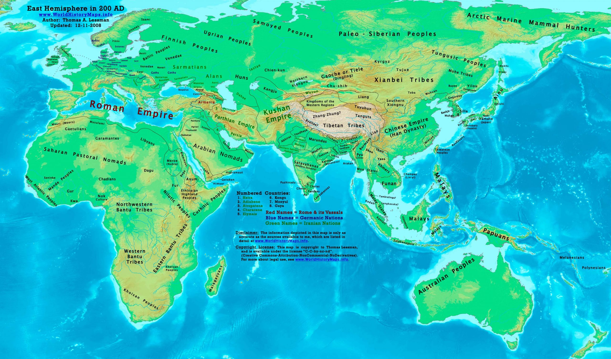
https://www.worldhistorymaps.info/wp-content/uploads/2021/03/map-200ad.jpg
Primary Sources for East-Hem_200ad.jpg:
- The DK Atlas of World History, 2000 Edition. Map of “The World in 250 CE”. Pgs 46-47
- John Nelson. Interactive Historical Atlas of the World since 500BCE. Map of “Countries of the World 1/1/200 CE.”
World History Maps Inc., Alexandria, VA, 2008. Available at www.WorldHistoryMaps.com.
- Euratlas. Periodical Historical Atlas of Europe. Map of “Europe in 200 AD”.
- Albert Herrmann, Ph.D. History & Commercial Atlas of China. Map of “Asia in 200 AD”.
Harvard University Press 1935. Available at http://huhai.net.
- User:Javierfv1212. Map of the “World_in_200_CE.PNG”. Available on Wikipedia.
- Bruce Gordon. Regnal Chronologies.
I – African information
* African Tribal locations are derived from:
- The DK Atlas of World History. Map of “Development of Complex Societies in Africa”. Pg 160.
(Bantus, Berbers, Chadians, Cushites, Garamantes, Gur, Khoisans, Mandes, Nilotics, West Atlantic Peoples, etc.)
- User:Javierfv1212. Map of the “World_in_200_CE.PNG”. Available on Wikipedia.
* North Africa borders and tribal locations are from:
- Euratlas. Periodical Historical Atlas of Europe. Map of “Europe in 200 AD”.
II – Asian Information
* Caucasian borders ( Albania , Armenia , Colchis , Iberia , and Lazica)
- Euratlas. Periodical Historical Atlas of Europe. Map of “Europe in 200 AD”.
* Central Asia peoples and borders are derived from:
- John Nelson. Interactive Historical Atlas of the World. Map of the “Countries of the World 1/1/200 CE.”
- Joseph Schwartzberg. The Historical Atlas of South Asia. Map of “The Satavahana-Saka-Kushana Age 1-300ad”.
- David Christian.A History of Russia, Central Asia, & Mongolia, Vol 1. . Pgs 210-218.
* Chinese Empire (Han Dynasty) borders:
- John Nelson. Interactive Historical Atlas of the World. Map of the “Countries of the World 1/1/200 CE.”
- Albert Herrmann, Ph.D. History & Commercial Atlas of China. Map of “Asia in 200 AD”.
* Greater India (Including modern Bangladesh, India, and Pakistan):
- John Nelson. Interactive Historical Atlas of the World. Map of the “Countries of the World 1/1/200 CE.”
- Joseph Schwartzberg. The Historical Atlas of South Asia. Map of “The Satavahana-Saka-Kushana Age 1-300ad”.
- User:Javierfv1212. Map of the “World_in_200_CE.PNG”. Available on Wikipedia.
- User:PHG. Maps of the “Satavahanas” and “Western Kshatrapas”. Available on Wikipedia.
* Korean borders derive from:
- Park Hyeon. Map of “History of Korea-204”. Available on Wikipedia.
* Kushan Empire borders are derived from a mix of the sources below:
- John Nelson. Interactive Historical Atlas of the World. Map of the “Countries of the World 1/1/200 CE.”
- The DK Atlas of World History (see above, #1 under Primary Sources).
- Albert Herrmann, Ph.D. History & Commercial Atlas of China. Map of “Asia in 200 AD”.
* Parthian Empire borders derive from:
- Eastern Parthian borders are from:
Albert Herrmann, Ph.D. History & Commercial Atlas of China. Map of “Asia in 200 AD”.
- Western Parthian borders are from:
Euratlas. Periodical Historical Atlas of Europe. Map of “Europe in 200 AD”.
* Roman Empire borders in Asia are derived from:
- Euratlas. Periodical Historical Atlas of Europe. Map of “Europe in 200 AD”.
- John Nelson. Interactive Historical Atlas of the World. Map of “Countries of the World 1/1/200 CE.”
* Southeast Asian borders: (Funan, Lâm Áp/Linyi, Malay Kingdoms, Pyu Cities, etc.)
- Joseph Schwartzberg. The Historical Atlas of South Asia. Map of “Southeast Asia to AD 650”. Pg 30.
- The DK Atlas of World History, 2000 edition. Map of “Southeast Asia to 650 CE”. Pg 241.
- Albert Herrmann, Ph.D. History & Commercial Atlas of China. Map of “Asia in 200 AD”.
- User:L_joo. Map of Funan. Available on Wikipedia.
III – European Information
* European information is derived from:
- Euratlas. Periodical Historical Atlas of Europe. Map of “Europe in 200 AD”.
- John Nelson. Interactive Historical Atlas of the World. Map of “Countries of the World 1/1/200 CE.”
World
Human population reaches about 257 million.
Roman Empire
Emperor Septimius Severus visits the provinces of Syria, Palestine, and Arabia.
The province of Numidia is taken from the African proconsul, and made an Imperial province.
India
Rudrasena I, Saka ruler of the Western Satrap dynasty, becomes king of Malwa in Classical India.
China
September-November – Battle of Guandu: Chinese warlord Cao Cao defeats his rival Yuan Shao.
Japan
In Japan, Himiko, whose capital is situated in Yamatai, extends her authority over a number of clans.
America
The Classic Age of Maya civilization begins (around this year).
The Paracas culture in the Andes ends (around this year).
Source: Wikipedia