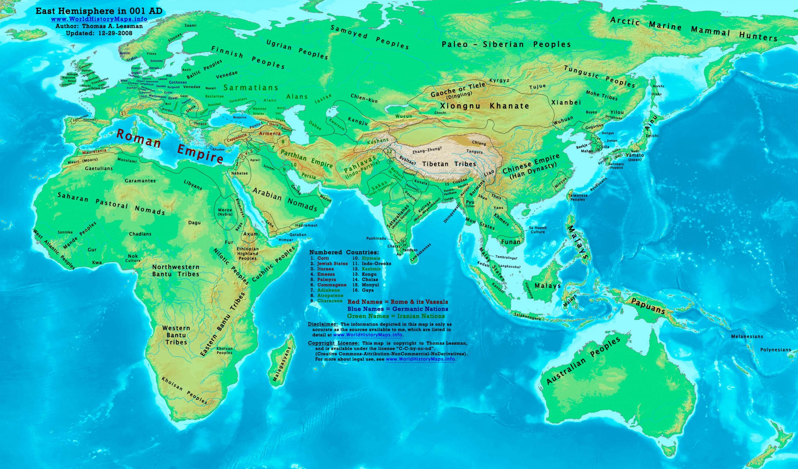
https://www.worldhistorymaps.info/wp-content/uploads/2021/03/map-1ad.jpg
Primary Sources for East-Hem_001ad.jpg:
- The DK Atlas of World History, 2000 Edition. Map of “The World in 1 CE”. (Pgs 42-43)
- John Nelson. Interactive Historical Atlas of the World since 500BCE. Map of “Countries of the World 1/1/001 CE.”
World History Maps Inc., Alexandria, VA, 2008. Available at www.WorldHistoryMaps.com.
- Euratlas. Periodical Historical Atlas of Europe. Map of “Europe in 001 AD”.
- User:Javierfv1212. Map of the “World_1_CE”. Available on Wikipedia.
- Bruce Gordon. Regnal Chronologies.
I – African information
* North Africa borders and tribal locations are from:
- Euratlas. Periodical Historical Atlas of Europe. Map of “Europe in 001 AD”.
* Sub-Saharan Africa tribal locations are from:
- The DK Atlas of World History. Map of “Development of Complex Societies in Africa”. Pg 160.
(Bantus, Berbers, Chadians, Cushites, Garamantes, Gur, Khoisans, Mandes, Nilotics, West Atlantic Peoples, etc.)
II – Asian Information
Note: Asian information is derived primarily from a combination of these sources:
- The DK Atlas of World History. Map of “The World in 1 CE”. Pgs 42-43.
- John Nelson. Interactive Historical Atlas of the World. Map of “Countries of the World 1/1/001 CE.”
* Caucasian borders ( Albania , Armenia , Colchis , Iberia , and Lazica)
- Euratlas. Periodical Historical Atlas of Europe. Map of “Europe in 001 AD”.
* Central Asia peoples and borders are derived from:
- John Nelson. Interactive Historical Atlas of the World. Map of the “Countries of the World 1/1/001 CE.”
- Joseph Schwartzberg. The Historical Atlas of South Asia. Map of “The Satavahana-Saka-Kushana Age 1-300ad”.
- David Christian.A History of Russia, Central Asia, & Mongolia, Vol 1. Pgs 210-218.
* Chinese Empire (Han Dynasty) borders:
- John Nelson. Interactive Historical Atlas of the World. Map of “Countries of the World 1/1/001 CE.”
* Greater India (Including modern Bangladesh, India, and Pakistan):
- Joseph Schwartzberg. The Historical Atlas of South Asia. Map of “The Satavahana-Saka-Kushana Age 1-300ad”.
- John Nelson. Interactive Historical Atlas of the World. Map of the “Countries of the World 1/1/001 CE.”
* Kashmir (Chach) is described in:
* Korean & Manchurian information is from:
- Park Hyeon. Historical Maps of Korea. Map of “History of Korea-001”. Available on Wikipedia
* Pahlava (Indo-Parthian) Empire borders derive from:
- John Nelson. Interactive Historical Atlas of the World. Map of “Countries of the World 1/1/001 CE.”
- Wikipedia. Article about the Indo-Parthian Kingdom.
- Encyclopaedia Iranica. Article about the Parthians. (States King Artabanus of Parthia faced the “Pahlava dynasty”,
possibly the Surena family, along the empire’s eastern border).
* Parthian Empire borders derive from:
- John Nelson. Interactive Historical Atlas of the World. Map of “Countries of the World 1/1/001 CE.”
- Wikipedia. Article about Parthia. 3. Encyclopaedia Iranica. Article about the Parthians.
* Southeast Asian borders: (Funan, Sa Huynh Culture, Malay Kingdoms, Pyu Cities, etc.)
- Joseph Schwartzberg. The Historical Atlas of South Asia. Map of “Southeast Asia to AD 650”. Pg 30.
- The DK Atlas of World History, 2000 edition. Map of “Southeast Asia to 650 CE”. Pg 241.
* Southwest Asia (Parthian Empire, Indo-Scythians, Tocharians/Yuezhi, etc.)
- Wikipedia. Articles about the Indo-Scythians, the Kushan Empire, and Kushan King Heraios.
- The DK Atlas of World History, 2000 edition. Map of “Wars of Parthia & Rome, 53 BCE -217 CE”. Pg 224.
III – European Information
* European information is derived from:
- Euratlas. Periodical Historical Atlas of Europe. Map of “Europe in 001 AD”.
- John Nelson. Interactive Historical Atlas of the World. Map of the “Countries of the World 1/1/001 CE.”
Note: Much of the information in this map was cross-checked with Bruce Gordon’s Regnal Chronologies.
Roman Empire
Tiberius, under order of Emperor Augustus, quells revolts in Germania (AD 1–5).[1]
Quirinius becomes a chief advisor to Gaius in Armenia.
Gnaeus Domitius Ahenobarbus serves in the Armenia campaigns.
Asia
Confucius is given his first royal title (posthumous name) of Lord Baochengxun Ni.
Sapadbizes, Yuezhi prince and king of Kush (Bactria), dies. Heraios succeeds him as king.
Africa
The Kingdom of Aksum, centered in modern-day Ethiopia and Eritrea, is founded (approximate date).
Amanishakheto, queen of Kush (Nubia), dies. Her son, Natakamani, becomes king of Kush.
Americas
Moxos ceases to be a significant religious area in South America (approximate date).[clarification needed]
The Teotihuacan culture in Mesoamerica begins (approximate date).
The Olmec 2 phase of the Olmec civilization begins; San Lorenzo and La Venta grow in population.
Source: Wikipedia