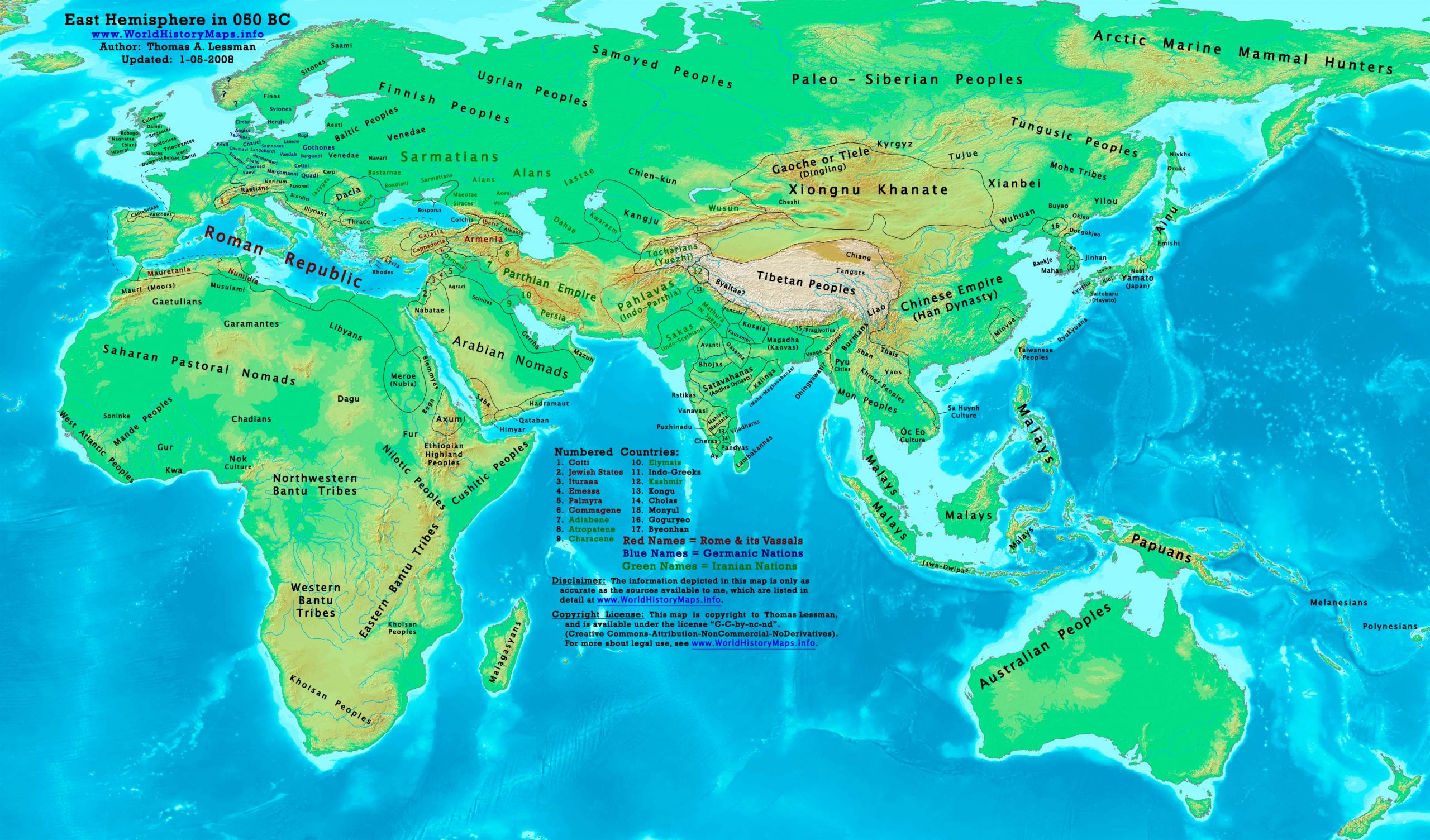
https://www.worldhistorymaps.info/wp-content/uploads/2021/03/map-050bc.jpg
Primary Sources for East-Hem_050bc.jpg:
- The DK Atlas of World History, 2000 Edition. Map of “The World in 1 CE”. Pgs 42-43.
- John Nelson. Interactive Historical Atlas of the World since 500BCE.
World History Maps Inc., Alexandria, VA, 2008. Available at www.WorldHistoryMaps.com.
- Euratlas. Periodical Historical Atlas of Europe. Map of “Europe in 001 AD”.
- User:Javierfv1212. Map of the “World_in_50_BCE.PNG”. Available on Wikipedia.
- Bruce Gordon. Regnal Chronologies.
I – African information
* North Africa borders and tribal locations are from:
- 1. John Nelson. Interactive Historical Atlas of the World. Map of “Countries of the World 1/1/050 BCE.”
- Euratlas. Periodical Historical Atlas of Europe. Map of “Europe in 001 AD”.
* Sub-Saharan Africa tribal locations are from:
- The DK Atlas of World History. Map of “Development of Complex Societies in Africa”. Pg 160.
(Bantus, Berbers, Chadians, Cushites, Garamantes, Gur, Khoisans, Mandes, Nilotics, West Atlantic Peoples, etc.)
II – Asian Information
Note: Asian information is derived primarily from a combination of these sources:
- The DK Atlas of World History, 2000 edition. Map of “The World in 1 CE”. Pgs 42-43.
- John Nelson. Interactive Historical Atlas of the World. Map of “Countries of the World 1/1/050 BCE.”
* Asia Minor (Anatolia) information (inc. Galatia, Cappadocia, Roman, & Armenian borders):
- 1. John Nelson. Interactive Historical Atlas of the World. Map of “Countries of the World 1/1/050 BCE.”
* Caucasian borders (Albania , Armenia , Colchis , Iberia , and Lazica)
- Euratlas. Periodical Historical Atlas of Europe. Map of “Europe in 001 AD”.
- John Nelson.Interactive Historical Atlas of the World. Map of the “Countries of the World 1/1/050 BCE.”
* Central Asia peoples and borders are derived from:
- John Nelson.Interactive Historical Atlas of the World. Map of “Countries of the World 1/1/050 BCE.”
- Joseph Schwartzberg. The Historical Atlas of South Asia. Map of “The Satavahana-Saka-Kushana Age 1-300ad”.
- Joseph Schwartzberg.The Historical Atlas of South Asia. Map of “Probable migrations to South Asia (200-1BC)”.
- David Christian.A History of Russia, Central Asia, & Mongolia, Vol 1. Pgs 173-180.
* Chinese Empire (Han Dynasty):
- Albert Herrmann, PhD. History & Commercial Atlas of China. Map of “Hsiung-nu in Central Asia, 128-36 BC”.
- John Nelson. Interactive Historical Atlas of the World. Map of “Countries of the World 1/1/050 BCE.”
- The DK Atlas of World History, 2000 Edition. Map of “The Han Empire”. Pg 260
* Greater India (Including modern Bangladesh, India, and Pakistan):
- Joseph Schwartzberg.The Historical Atlas of South Asia. Map of “Probable migrations to South Asia (c200-1BC)”.
- Joseph Schwartzberg.The Historical Atlas of South Asia. Map of “The Satavahana-Saka-Kushana Age 1-300ad”.
- John Nelson. Interactive Historical Atlas of the World. Map of the “Countries of the World 1/1/049 BCE.”
* Indo-Greek Kingdoms are derived from:
- Joseph Schwartzberg. The Historical Atlas of South Asia. Map of “Probable migrations to South Asia (c200-1BC)”.
- John Nelson. Interactive Historical Atlas of the World. Map of “Countries of the World 1/1/100 BCE.”
- Rama Shankar Tripathi.History of Ancient India. Pgs 202-211.
* Korean & Manchurian information is from:
- Park Hyeon. Historical Maps of Korea. Map of “History of Korea-050 BC”. Available on Wikipedia
* Pahlava (Indo-Parthian) Empire borders derive from:
- John Nelson. Interactive Historical Atlas of the World. Map of “Countries of the World 1/1/049 BCE.”
- Wikipedia. Article about the Indo-Parthian Kingdom.
- Encyclopaedia Iranica. Article about the Parthians. (States King Artabanus of Parthia faced the “Pahlava dynasty”,
possibly the Surena family, along the empire’s eastern border).
* Parthian Empire borders derive from:
- John Nelson. Interactive Historical Atlas of the World. Map of “Countries of the World 1/1/050 BCE.”
- Wikipedia. Article about Parthia. 3. Encyclopaedia Iranica. Article about the Parthians.
* Southeast Asian borders: (Funan, Sa Huynh Culture, Malay Kingdoms, Pyu Cities, etc.)
- Joseph Schwartzberg. The Historical Atlas of South Asia. Map of “Southeast Asia to AD 650”. Pg 30.
- The DK Atlas of World History, 2000 edition. Map of “Southeast Asia to 650 CE”. Pg 241.
III – European Information
* European information is derived from:
- 1. John Nelson.Interactive Historical Atlas of the World. Map of “Countries of the World 1/1/050 BCE.”
- Euratlas. Periodical Historical Atlas of Europe. Map of “Europe in 001 AD”.
* Dacian borders are derived from:
Note: Much of the information in this map was cross-checked with Bruce Gordon’s Regnal Chronologies.
Roman Republic
Consuls: Lucius Aemilius Paullus and Gaius Claudius Marcellus.
The Senate refuses Julius Caesar permission to stand for consul in absentia, and demands that he lay down his command.
The Roman artillery piece called Scorpio is invented.
Initiation Rites of the Cult of Bacchus, detail of a wall painting in the Villa of the Mysteries, Pompeii, is made (approximate date).
The Roman Republic takes control of Judea (approximate date).
Source: Wikipedia