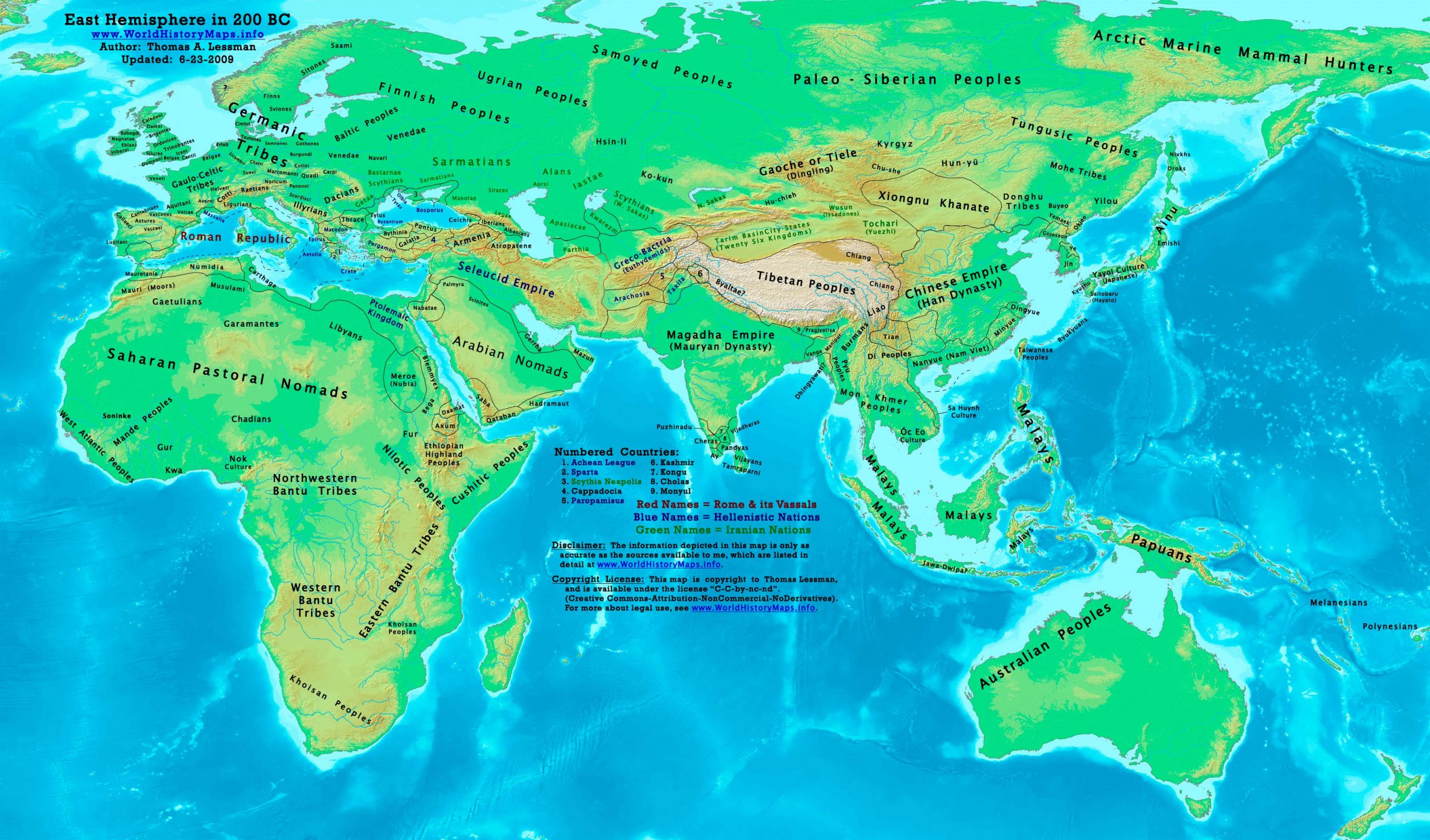
https://www.worldhistorymaps.info/wp-content/uploads/2021/03/map-200bc.jpg
Primary Sources for East-Hem_200bc.jpg:
- DK Atlas of World History, 2000 edition. Map of “The World in 250 BCE ”. (Pg 38)
- The New Penguin Atlas of Ancient History, 2002 edition. Map of “The Near East in 192 BC ”. (Pg 85)
- John Nelson. Interactive Historical Atlas of the World since 500BCE. Map of the “Countries of the World 1/1/200 BCE.”
World History Maps Inc., Alexandria, VA, 2008. Available at www.WorldHistoryMaps.com.
- Albert Herrmann, Ph.D. History & Commercial Atlas of China. Map of the “Northern Borders of the Steppes, 174 BC”.
Harvard University Press 1935. Available at http://huhai.net.
- User:Javierfv1212. Map of the “World_200_BCE”. Available on Wikipedia.
I – African information
- DK Atlas of World History, 2000 edition. Maps of:
* “The World in 250 BCE ”. (Pg 38)
Axum, Bantu Tribes, Cushites, Nilotic Peoples, etc.
* “Berber states in North Africa ”. (Pg 161)
Carthage, Mauretania, Numidia, Ptolemaic Empire, etc.
* “The Development of complex societies in Africa ”. (Pg 160)
Garamantes, Gur, Kwa, Mandes, Nok, Khoisan Peoples, West Atlantic Peoples, etc.
- User:Javierfv1212. Map of the “World_200_BCE”. Available on Wikipedia.
Bantu Tribes, Khoisan Pastoral Farmers, Saharan Pastoral Nomads, etc.
II – Asian Information
* Central & Northern Asia (including the Steppes):
- Albert Herrmann, Ph.D. History & Commercial Atlas of China. Map of the “Northern Borders of the Steppes, 174 BC”.
Harvard University Press 1935. Available at http://huhai.net.
(Albani, Apasiacae, Chiang, Dingling, Donghu, Hsin-li, Hu-chieh, Hun-yu, Scythians, Tocharian/Yuezhi, Wusun, Xiongnu, etc.)
* Chinese (Han Dynasty) borders:
- Wikimedia’s map of the Qin_empire_210_BCE.png, and from
- The DK Atlas of World History, 2000 Edition. Map of “The Han Empire”. (Pg 260)
- John Nelson. Interactive Historical Atlas of the World. Map of “Countries of the World 1/1/200 BCE.”
* Greco-Bactrian information is derived from:
- Joseph Schwartzberg. The Historical Atlas of South Asia. Map of “Probable migrations to South Asia (c200-1BC)”.
- John Nelson. Interactive Historical Atlas of the World. Map of “Countries of the World 1/1/200 BCE.”
- Rama Shankar Tripathi.History of Ancient India. Pgs 202-211.
* Korean and Manchurian information:
- Park Hyeon. Map of “History_of_Korea-108BC”.
Note: The borders were similar 100 years prior. (Buyeo, Gojoseon, Jin, Yemaek, Yilou, etc.)
* Nan-Yue/Nam Viet borders
- The DK Atlas of World History, 2000 Edition. Map of “The Han Empire”. (Pg 260)
* Seleucid Empire borders derive from:
- The DK Atlas of World History. Map of “Alexander’s Successors from 301 BCE ”. Pg 225.
- John Nelson. Interactive Historical Atlas of the World. Map of “Countries of the World 1/1/200 BCE.”
- This map of the Seleucid Empire.
- Wikipedia. Article about “Antiochus III the Great”.
* South Asia/India, (including: Mauryan Empire, Cholas, Kalinga, Kerala, Pandyas, and Satiyaputra)
- This map of India in 250 BC.
III – European Information
* Roman Republic borders:
- The DK Atlas of World History, 2000 Edition. Maps of “1st & 2nd Punic Wars” (pg 179)
and “Roman Conquests to 120 BC” (pg 179).
Note: Much of the information in this map was cross-checked with Bruce Gordon’s Regnal Chronologies.
200 BC: Battle of Panium: Antiochus III of the Seleucid empire defeats Ptolemy V of Egypt
Seleucid Empire
Antiochus III’s forces continue their invasion of Coele Syria and Palestine.
Conquest of Armenia by the Seleucids
Greece
Philip V of Macedon’s fleet defeat the Rhodians at Lade. His forces then advance into Pergamum, plundering Pergamese territory and attacking cities in Caria.
The Acarnanians, with Macedonian support, invade Attica, causing Athens, which has previously maintained its neutrality, to seek help from the enemies of Philip. Attalus I of Pergamum, who is with his fleet at Aegina, receives an embassy from Athens asking him to come to the city for consultations. After he is told that Roman ambassadors are also in Athens, Attalus goes there in haste.
The Roman ambassador to Greece, Syria, and Egypt, Marcus Aemilius Lepidus delivers an ultimatum to Philip V warning Macedonia not to make war on any Greek state. Philip decides to reject the Roman ultimatum and the Romans declare war on Macedon, thus starting the Second Macedonian War.
The Roman consul, Publius Sulpicius Galba Maximus, asks Attalus I and his fleet to meet up with the Roman fleet off the Greek Aegean coast and they conduct a naval campaign against Philip V, harassing Macedonian possessions in and along the Aegean.
Source: Wikipedia