
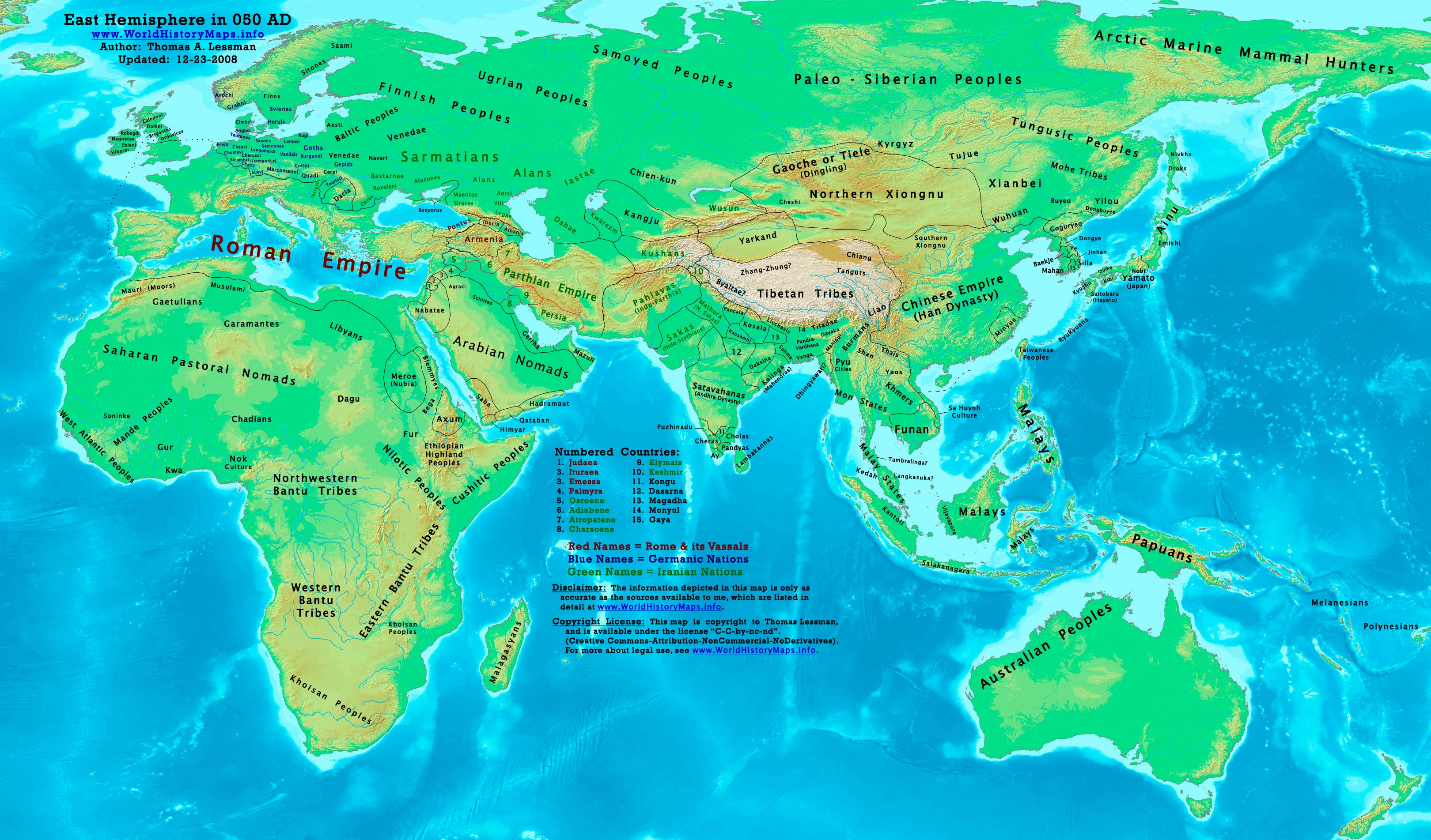
https://www.worldhistorymaps.info/wp-content/uploads/2021/03/map-50ad.jpg
Primary Sources for East-Hem_050ad.jpg:
- John Nelson. Interactive Historical Atlas of the World since 500BCE. Map of “Countries of the World 1/1/050 CE.”
World History Maps Inc., Alexandria, VA, 2008. Available at www.WorldHistoryMaps.com.
- Euratlas. Periodical Historical Atlas of Europe. Comparison of maps “Europe in 100 AD” and “Europe in 001 AD”.
- Joseph Schwartzberg. The Historical Atlas of South Asia.
- User:Javierfv1212. Map of the “World_in_50_CE.PNG”. Available on Wikipedia.
- Bruce Gordon. Regnal Chronologies.
I – African information
* North Africa borders and tribal locations are from:
- Euratlas. Periodical Historical Atlas of Europe. Maps of “Europe in 001 AD” and “Europe in 100 AD”.
* Sub-Saharan Africa tribal locations are from:
- The DK Atlas of World History. Map of “Development of Complex Societies in Africa”. Pg 160.
(Bantus, Berbers, Chadians, Cushites, Garamantes, Gur, Khoisans, Mandes, Nilotics, West Atlantic Peoples, etc.)
II – Asian Information
* Caucasian borders ( Albania , Armenia , Colchis , Iberia , and Lazica)
- Euratlas. Periodical Historical Atlas of Europe. Map of “Europe in 001 AD” and “Europe in 100 AD”.
* Central Asia peoples and borders are derived from:
- John Nelson.Interactive Historical Atlas of the World. Map of the “Countries of the World 1/1/050 CE.”
- Joseph Schwartzberg. The Historical Atlas of South Asia. Map of “The Satavahana-Saka-Kushana Age 1-300ad”.
- David Christian.A History of Russia, Central Asia, & Mongolia, Vol 1. Pgs 210-218.
* Chinese Empire (Han Dynasty) borders:
- John Nelson. Interactive Historical Atlas of the World. Map of “Countries of the World 1/1/050 CE.”
* Greater India (Including modern Bangladesh, India, and Pakistan):
- Joseph Schwartzberg. The Historical Atlas of South Asia. Map of “The Satavahana-Saka-Kushana Age 1-300ad”.
- John Nelson. Interactive Historical Atlas of the World. Map of “Countries of the World 1/1/050 CE.”
* Korean borders derive from:
- Park Hyeon. Comparison of map of “History of Korea-001” and “History of Korea-100”. Available on Wikipedia.
* Pahlava (Indo-Parthian) Empire borders derive from:
- John Nelson. Interactive Historical Atlas of the World. Map of “Countries of the World 1/1/045 CE.”
- Wikipedia. Article about the Indo-Parthian Kingdom.
- Encyclopaedia Iranica.Article about the Parthians. (States that the Parthian King Artabanus faced the “Pahlava”
dynasty, possibly the Surena family, along the empire’s eastern border).
* Parthian Empire borders derive from:
- John Nelson. Interactive Historical Atlas of the World. Map of “Countries of the World 1/1/050 CE.”
- Wikipedia. Article about Parthia. 3. Encyclopaedia Iranica. Article about the Parthians.
* Southeast Asian borders: (Funan, Lâm Áp/Linyi, Malay Kingdoms, Pyu Cities, etc.)
- Joseph Schwartzberg. Historical Atlas of South Asia. Map of “Southeast Asia to AD 650”. Pg 30.
- The DK Atlas of World History, 2000 edition. Map of “Southeast Asia to 650 CE”. Pg 241.
III – European Information
* European information is derived from:
- Euratlas. Periodical Historical Atlas of Europe. Comparison of maps “Europe in 001 AD” & “Europe in 100 AD”.
Note: Much of the information in this map was cross-checked with Bruce Gordon’s Regnal Chronologies.
Roman Empire
Cologne is raised to the status of a city.
Utrecht is founded, and a Roman fortification (castellum) is constructed at the Rhine border in the present-day Netherlands.
Claudius adopts Nero.
In Judea a Roman soldier seizes and burns a Torah-scroll. Procurator Cumanus has the culprit beheaded, calming down the Jews and delaying for two decades the outbreak of their revolt.[1]
In Britain, governor Publius Ostorius Scapula begins his campaign against the recalcitrant Silures of south Wales, who are led by the former Catuvellaunian prince Caratacus. London (Londinium), Exeter (Isca Dumnoniorum), Tripontium (near modern Rugby) and the fort of Manduessedum (near modern Atherstone) are founded (approximate date).
Roman emperor Claudius appoints Agrippa II governor of Chalcis.
Romans build a wooden bridge across the Thames in the London area.
South Asia
The Yuezhi tribes are united under the Kushan leader Kujula Kadphises, thus creating the Kushan Empire in Afghanistan and northern India. (approximate date)
Americas
San Bartolo pyramid is completed around this time.
Source: Wikipedia