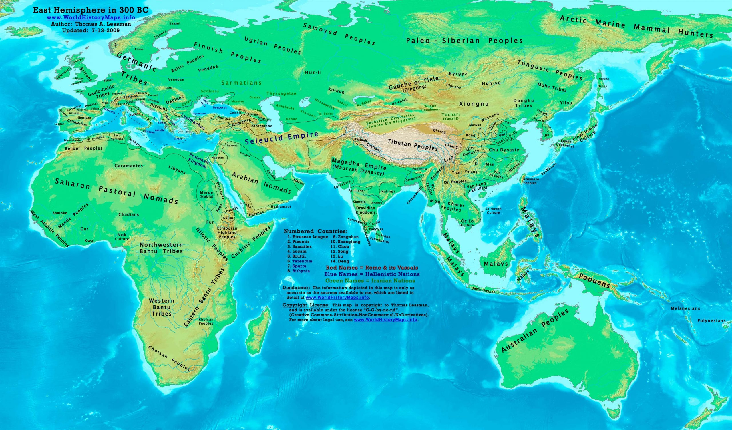
https://www.worldhistorymaps.info/wp-content/uploads/2021/03/map-300bc.jpg
Primary Sources for East-Hem_300bc.jpg:
- The DK Atlas of World History, 2000 edition. (See specific references below)
- John Nelson. Interactive Historical Atlas of the World since 500BCE. Map of the “Countries of the World 1/1/300 BCE.”
World History Maps Inc., Alexandria, VA, 2008. Available at www.WorldHistoryMaps.com.
- The New Penguin Atlas of Ancient History, 2002 edition. Map of “The Near East in 301 BC ”. (Pg 77)
- User:Javierfv1212. Map of the “World_in_300_BCE”. Available on Wikipedia.
I – African information:
* African Tribal locations are derived from:
- The DK Atlas of World History. Map of “The Development of Complex Societies in Africa”. (Pg 160).
(Bantus, Berber Tribes, Chadians, Cushites, Daamat, Garamantes, Gur, Khoisan Peoples, Kwa, Libyans, Mandes,
Nilotic Peoples, West Atlantic Peoples, etc.)
* Ptolemaic Egypt borders are derived from:
- The DK Atlas of World History. Map of “Alexander’s Successors from 301 BCE”. (Pg 224).
- John Nelson. Interactive Historical Atlas of the World. Map of “Countries of the World 1/1/300 BCE.”
II – Asian information:
* East Asia (Zhou China) borders:
- Wikimedia’s map of the Qin_empire_210_BCE.png, and from
- The DK Atlas of World History, 2000 Edition. Map of “The Han Empire”. (Pg 260)
- John Nelson. Interactive Historical Atlas of the World. Map of “Countries of the World 1/1/300 BCE.”
* Greater India (Including modern Bangladesh, India, and Pakistan):
- The DK Atlas of World History. Map of “The Nanda and Mauryan Empires, 365-181 BCE ”. Pg 241.
- Joseph Schwartzberg. The Historical Atlas of South Asia. Map of “The Achaemenid Empire and the Magadhan Empire“.
- John Nelson. Interactive Historical Atlas of the World. Map of “Countries of the World 1/1/300 BCE.”
* Korean & Manchurian information:
- Park Hyeon. Map of “History_of_Korea_300_BC.png”. Available on Wikipedia.
III – European information:
* Roman Republic borders are from:
- The DK Atlas of World History, 2000 edition. Map of “ Italy in 240 BCE ”. (Also shows Roman borders in 300 BCE ).
- John Nelson. Interactive Historical Atlas of the World. Map of “Countries of the World 1/1/300 BCE.”
Note: Much of the information in this map was cross-checked with Bruce Gordon’s Regnal Chronologies.
Greece
Pilgrims travel to the healing temples of Asclepieion to be cured of their ills. After a ritual purification the followers bring offerings or sacrifices.
Egypt
Pyrrhus, the King of Epirus, is taken as a hostage to Egypt after the Battle of Ipsus and makes a diplomatic marriage with the princess Antigone, daughter of Ptolemy and Berenice.
Ptolemy concludes an alliance with King Lysimachus of Thrace and gives him his daughter Arsinoe II in marriage.
Seleucid Empire
Seleucus founds the city of Antioch, some 20 miles up the Orontes River, naming it after his father.
After the death of his wife Apama, Seleucus marries Stratonice, daughter of Demetrius Poliorcetes.
India
The central texts of Jainism, the Jain scriptures, are recorded (approximate date)
Source: Wikipedia