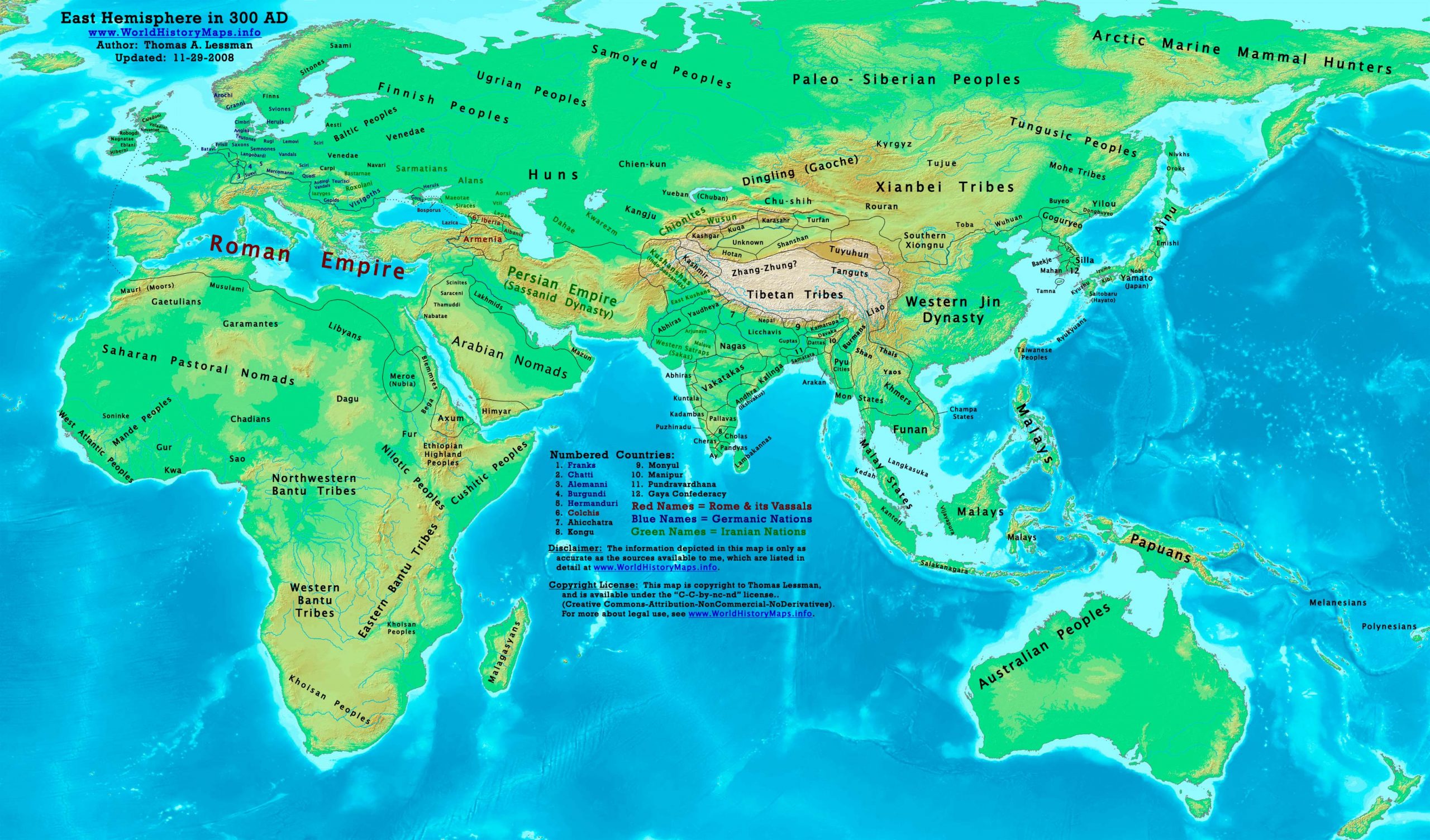
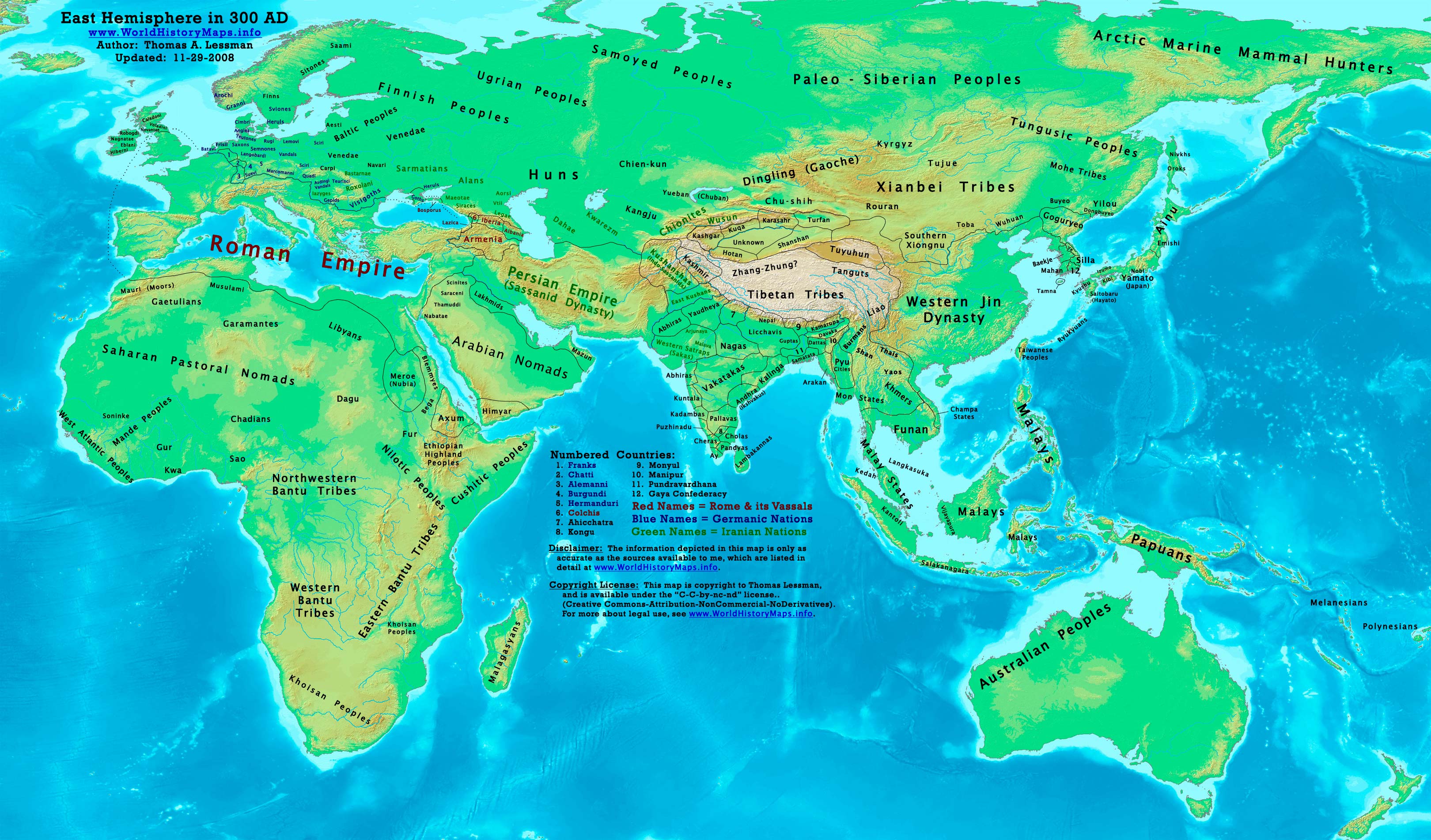
https://www.worldhistorymaps.info/wp-content/uploads/2021/03/map-300ad.jpg
Primary Sources for East-Hem_300ad.jpg:
- The DK Atlas of World History, 2000 Edition. Map of “The World in 250 CE”. (Pgs 46-47).
- John Nelson. Interactive Historical Atlas of the World since 500BCE. Map of “Countries of the World 1/1/300 CE.”
World History Maps Inc., Alexandria, VA, 2008. Available at www.WorldHistoryMaps.com.
- Euratlas. Periodical Historical Atlas of Europe. Map of “Europe in 300 AD”.
- User:Javierfv1212. Map of the “World_in_300_CE.PNG”. Available on Wikipedia.
- Bruce Gordon. Regnal Chronologies.
I – African information
* African Tribal locations are derived from:
- The DK Atlas of World History. Map of “Development of Complex Societies in Africa”. Pg 160.
(Bantus, Berbers, Chadians, Cushites, Garamantes, Gur, Khoisans, Mandes, Nilotics, West Atlantic Peoples, etc.)
- User:Javierfv1212. Map of the “World_in_300_CE.PNG”. Available on Wikipedia.
II – Asian Information
* Caucasian borders ( Albania , Armenia , Colchis , Iberia , and Lazica)
- Euratlas. Periodical Historical Atlas of Europe. Map of “Europe in 300 AD”.
* Central Asia peoples and borders are derived from:
- John Nelson. Interactive Historical Atlas of the World. Map of the “Countries of the World 1/1/300 CE.”
- Joseph Schwartzberg. The Historical Atlas of South Asia. Map of “The Satavahana-Saka-Kushana Age 1-300ad”.
- David Christian.A History of Russia, Central Asia, & Mongolia, Vol 1. . Pgs 210-218.
* Chinese (Western Jin Dynasty) borders:
- Albert Herrmann, Ph.D. History & Commercial Atlas of China. Map of “The Western Jin Dynasty, 265-315 AD”.
* Greater India (Including modern Bangladesh, India, and Pakistan):
- John Nelson. Interactive Historical Atlas of the World. Map of the “Countries of the World 1/1/300 CE.”
- Joseph Schwartzberg. The Historical Atlas of South Asia. Map of “The Satavahana-Saka-Kushana Age 1-300ad”
- This map of the “Expansion of the Guptas”. Available at Mapas Imperiales.
Note: I do not know what source info was used in t”Expansion of the Guptas”, nor whom the author is.
The map depicts kingdoms conquered by Gupta expansion, most of the kingdoms existed in 300 AD.
* Korean borders derive from:
- Park Hyeon. Map of “History of Korea-315”. Available on Wikipedia.
Note: Borders of the Daifang Commandery are from his “History of Korea-204” map. Available on Wikipedia.
* Kushanshas & East Kushans derive from:
- John Nelson. Interactive Historical Atlas of the World. Map of the “Countries of the World 1/1/300 CE.”
Note: The kingdom of “Takasila” (240-464 AD) corresponds to the East Kushans.
- Wikipedia. Article on the Kushan Empire.
Note: Article states the Kushan Empire split into 2 kingdoms after 225. The Western Kushans (in Afghanistan)
became vassals of the Sassanids by 244 AD, and thereafter were known as Kushanshas (or Indo-Sassanids).
The East Kushans (in India’s Punjab region) became Gupta vassals, then fell to the Kidarites by 420 AD.
* Lakhmid borders:
Note: States king Imru’ al-Qais I ibn ‘Amr (r. 288-328 AD) expanded his power along the coast to Bahrain.
* Persian Empire (Sassanid Dynasty) borders are from a combination of:
- Eastern Sassanid borders are based on:
John Nelson. Interactive Historical Atlas of the World. Map of the “Countries of the World 1/1/300 CE.”
- Western Sassanid borders are based on:
Euratlas. Periodical Historical Atlas of Europe. Map of “Europe in 300 AD”.
* Southeast Asian borders: (Funan, Champa/Lâm Áp/Linyi, Malay Kingdoms, Pyu Cities, etc.)
- Joseph Schwartzberg. The Historical Atlas of South Asia. Map of “Southeast Asia to AD 650”. Pg 30.
- The DK Atlas of World History, 2000 ed. Map of ” Southeast Asia to 650 CE”. Pg 241.
- User:L_joo. Map of Funan. Available on Wikipedia.
* Tarim Basin Kingdoms: (Hotan, Karaxahr, Kashgar, Kuqa, Shanshan, Turfan, etc.)
- User:Schreiber. Map of “The Tarim Basin, 3rd Century CE”. Available on Wikipedia.
* Yueban/Xiongnu are described in
- Wikipedia. Article about Yueban (Chumuhun).
III – European Information
* European information is derived from:
- Euratlas. Periodical Historical Atlas of Europe. Map of “Europe in 300 AD”.
- Wikipedia. Articles about Scandinavian history.
Note: Much of the information in this map was cross-checked with Bruce Gordon’s Regnal Chronologies.
Roman Empire
The Franks penetrate into what is now northern Belgium (approximate date).
The city of Split is built.
The Camp of Diocletian is built in Palmyra.
A Romano-Celtic[citation needed] temple-mausoleum complex is constructed in what is now Lullingstone, and also in Anderitum (approximate date).
Asia
The lion becomes extinct from Armenia (approximate date).
The Yayoi period ends in Ancient Japan (approximate date).
Wootz steel is developed in India (approximate date).
The Kama Sutra, an Indian handbook on the art of sexual love, is probably produced around this time by the sage Vatsyayana.
Micheon becomes ruler of the Korean kingdom of Goguryeo.[1]
Africa
The elephant becomes extinct in North Africa (approximate date).
The Atlas wild ass becomes extinct (approximate date).
America
The Formative/Preclassic period in Mesoamerica comes to an end (around this year).
The Mayan civilization reaches its most prolific period, the classic period, in what is now Guatemala, Belize and parts of southern Mexico adjacent to the former two. During most of this period, Tikal dominates the Mayan world.
Source: Wikipedia