
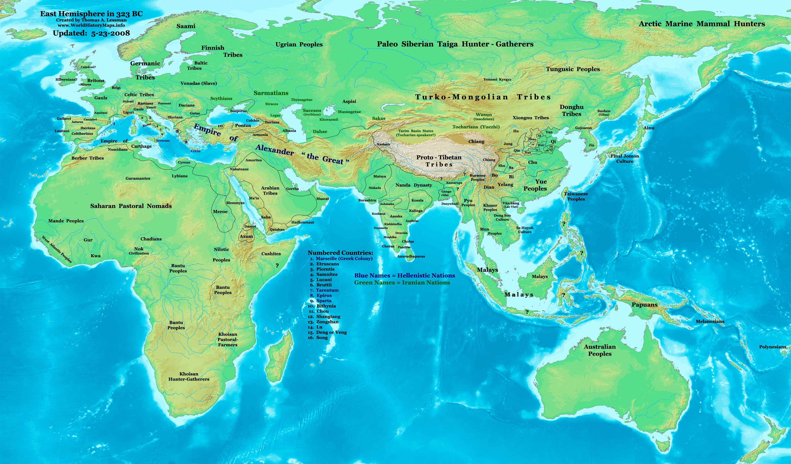
https://www.worldhistorymaps.info/wp-content/uploads/2021/03/map-323bc.jpg
Primary Sources for East-Hem_323bc.jpg:
- The DK Atlas of World History, 2000 edition. (See specific references below)
- John Nelson. Interactive Historical Atlas of the World since 500BCE. Map of the “Countries of the World 1/1/323 BCE.”
World History Maps Inc., Alexandria, VA, 2008. Available at www.WorldHistoryMaps.com.
- The New Penguin Atlas of Ancient History, 2002 edition. Map of “The Near East in 323 BC ”. (Pg 75)
- User:Briangotts. Map of “World_323_BCE”. Available on Wikipedia.
- User:Javierfv1212. Map of the “World_in_300_BCE”. Available on Wikipedia.
I – African information
* African Tribal locations are derived from:
- The DK Atlas of World History. Map of “The Development of Complex Societies in Africa”. (Pg 160).
(Bantus, Berber Tribes, Chadians, Cushites, Daamat, Garamantes, Gur, Khoisan Peoples, Kwa, Libyans, Mandes,
Nilotic Peoples, West Atlantic Peoples, etc.)
II – Asian Information
* East Asian (Chinese area) information is from:
- The DK Atlas of World History. Map of “Zhou China, 1027-403 BCE”. Pg 259.
- Albert Herrmann, Ph.D. History & Commercial Atlas of China. Map of “The Contending States Boundries c. 350 BC”.
- John Nelson. Interactive Historical Atlas of the World. Map of “Countries of the World 1/1/323 BCE.”
* Greater India (Including modern Bangladesh, India, and Pakistan):
- Gangaridai borders are not shown on any maps I’ve seen. They are described vaguely in these sources:
a – Dr. Harihar Kanungo. Article about “The Origins of the Ganga Dynasty – A New Insight”. Pg 25, section a.
b – Missouri Southern State University. Article about “Gangaridae in Megasthenes’ Indica”. Section 37.
c – History of Bengal website. (Contains extensive info on an archeological site called Chandraketurgarh,
(which may be the lost city of Ganga, the capital of Gangaridai).
- Indian Kingdoms general locations are derived from:
a – John Nelson. Interactive Historical Atlas of the World. Map of “Countries of the World 1/1/323 BCE.”
b – Wikipedia. Map of “Epic India”.
- Nanda Dynasty borders are derived from:
a – The DK Atlas of World History. Map of “The Nanda and Mauryan Empires, 365-181 BCE ”. Pg 241.
b – Joseph Schwartzberg. The Historical Atlas of South Asia. Map of “The Achaemenid Empire and the Magadhan Empire“.
c – John Nelson. Interactive Historical Atlas of the World. Map of “Countries of the World 1/1/323 BCE.”
* Korean & Manchurian information:
- Park Hyeon. Map of “History_of_Korea_300_BC.png”. Available on Wikipedia.
* Văn Lang borders are derived from:
- User:Briangotts. Map of “Van Lang”. Available on Wikipedia.
- Wikipedia. Articles about Văn Lang and the Hồng Bàng Dynasty.
III – European Information
* Alexander’s Empire borders in Europe are from:
- The DK Atlas of World History, 2000 Edition. Map of “Alexander’s Empire and successors”. (Pg 224).
- John Nelson. Interactive Historical Atlas of the World. Map of “Countries of the World 1/1/323 BCE.”
- The New Penguin Atlas of Ancient History, 2002 edition. Map of “The Near East in 323 BC ”. (Pg 75)
- Historical Atlas by William Shepherd. 1926 Edition. Map of “The Macedonian Empire, 336-323 BC”. Pgs 18-19
- Wikipedia. Map of “The Empire of Alexander the Great”. Author: User:Captain_Blood.
* Roman Republic borders are derived from:
- The DK Atlas of World History. 2000 Edition. Map of “ Italy in 240 BCE ”. (Pg 178). (Also shows Roman borders in 300 BCE ).
- John Nelson. Interactive Historical Atlas of the World. Map of “Countries of the World 1/1/323 BCE.”
Note: Much of the information in this map was cross-checked with Bruce Gordon’s Regnal Chronologies.
10 June/11 June – In Babylon, Alexander the Great dies, ten days after being taken ill after a prolonged banquet and drinking bout. Diogenes, the philosopher he met years before just about when he was to set out on his conquests, allegedly dies on the exact same day.
The Partition of Babylon sets out the division of the territories conquered by Alexander the Great between his generals. The partition is a result of a compromise, essentially brokered by Eumenes, following a conflict of opinion between the party of Meleager, who wishes to give full power to Philip III (the illegitimate son of King Philip II of Macedon by Philinna of Larissa), and the party of Perdiccas, who wishes to wait for the birth of the heir of Alexander and his wife, Roxana (the future Alexander IV) to give him the throne under the control of a regent.
Under the agreement, Philip III becomes king, but Perdiccas, as the regent, effectively becomes the ruler of Alexander’s empire. Perdiccas manages the partition of the territories between the former generals and [[saintly with Alexander’s chief lieutenant Craterus);
Source: Wikipedia