
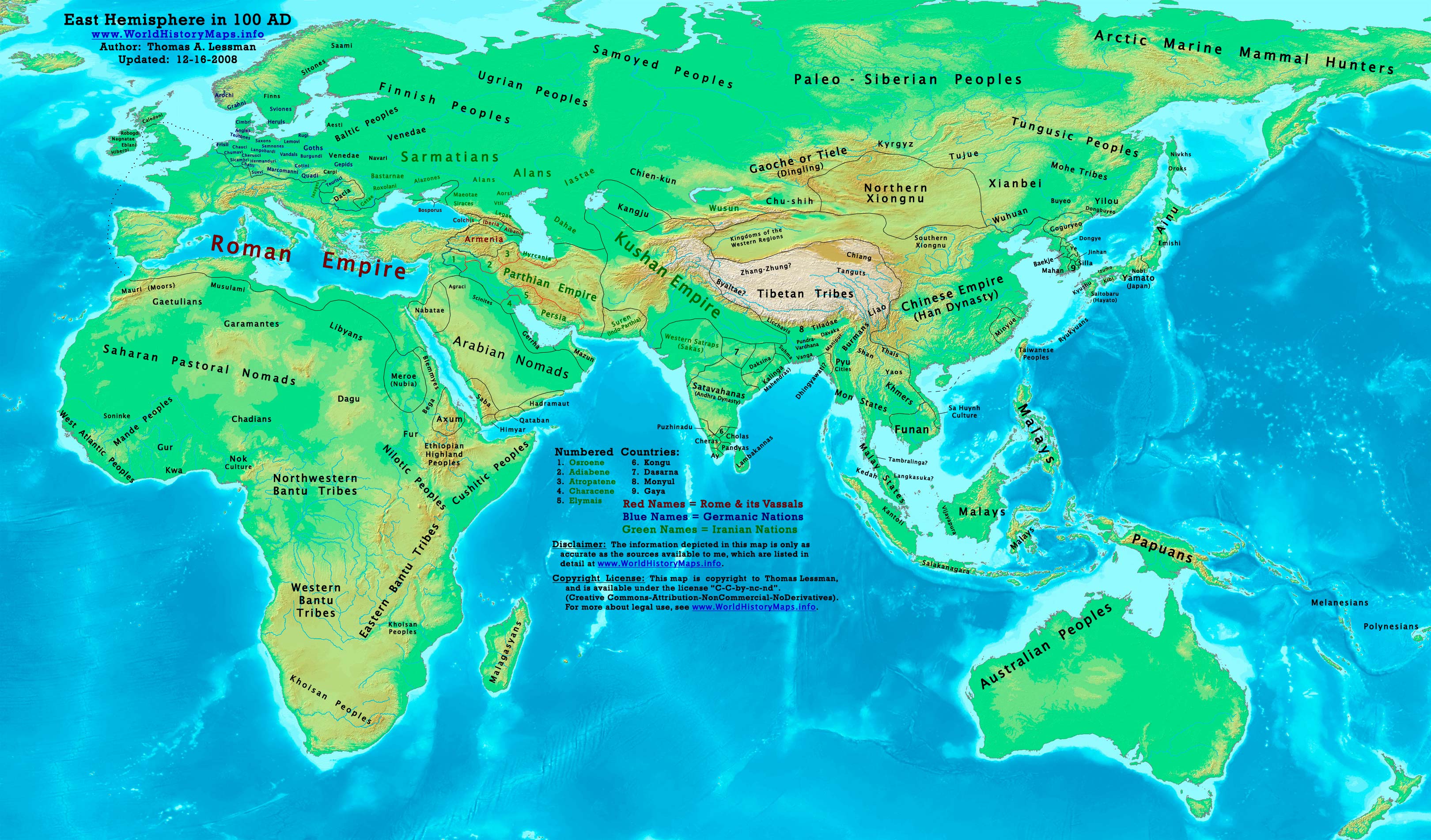
https://www.worldhistorymaps.info/wp-content/uploads/2021/03/map-100ad.jpg
Primary Sources for East-Hem_100ad.jpg:
- John Nelson. Interactive Historical Atlas of the World since 500BCE. Map of “Countries of the World 1/1/100 CE.”
World History Maps Inc., Alexandria, VA, 2008. Available at www.WorldHistoryMaps.com.
- Euratlas. Periodical Historical Atlas of Europe. Map of “Europe in 100 AD”.
- The DK Atlas of World History, 2000 Edition.
- User:Javierfv1212. Map of the “World_1_CE.PNG”. Available on Wikipedia.
- Bruce Gordon. Regnal Chronologies.
I – African information
* North Africa borders and tribal locations are from:
- Euratlas. Periodical Historical Atlas of Europe. Map of “Europe in 100 AD”.
* Sub-Saharan Africa tribal locations are from:
- The DK Atlas of World History. Map of “Development of Complex Societies in Africa”. Pg 160.
(Bantus, Berbers, Chadians, Cushites, Garamantes, Gur, Khoisans, Mandes, Nilotics, West Atlantic Peoples, etc.)
II – Asian Information
* Caucasian borders ( Albania , Armenia , Colchis , Iberia , and Lazica)
- Euratlas. Periodical Historical Atlas of Europe. Map of “Europe in 100 AD”.
* Central Asia peoples and borders are derived from:
- John Nelson. Interactive Historical Atlas of the World. Map of the “Countries of the World 1/1/100 CE.”
- Joseph Schwartzberg. The Historical Atlas of South Asia. Map of “The Satavahana-Saka-Kushana Age 1-300ad”.
- David Christian.A History of Russia, Central Asia, & Mongolia, Vol 1. . Pgs 210-218.
* Chinese Empire (Han Dynasty) borders:
- John Nelson. Interactive Historical Atlas of the World. Map of “Countries of the World 1/1/100 CE.”
* Greater India (Including modern Bangladesh, India, and Pakistan):
- Joseph Schwartzberg. The Historical Atlas of South Asia. Map of “The Satavahana-Saka-Kushana Age 1-300ad”.
- John Nelson. Interactive Historical Atlas of the World. Map of “Countries of the World 1/1/100 CE.”
* Korean borders derive from:
- Park Hyeon. Map of “History of Korea-100”. Available on Wikipedia.
* Kushan Empire borders are derived from a mix of the sources below:
- Joseph Schwartzberg.The Historical Atlas of South Asia. Map of “The Satavahana-Saka-Kushana Age 1-300ad”.
- John Nelson. Interactive Historical Atlas of the World. Map of “Countries of the World 1/1/100 CE.”
* Parthian Empire borders derive from:
- Eastern Parthian borders are from:
John Nelson. Interactive Historical Atlas of the World. Map of “Countries of the World 1/1/100 CE.”
- Western Parthian borders are from:
Euratlas. Periodical Historical Atlas of Europe. Map of “Europe in 100 AD”.
* Roman Empire borders in Asia are derived from:
- Euratlas. Periodical Historical Atlas of Europe. Map of “Europe in 100 AD”.
- John Nelson. Interactive Historical Atlas of the World. Map of “Countries of the World 1/1/100 CE.”
* Southeast Asian borders: (Funan, Lâm Áp/Linyi, Malay Kingdoms, Pyu Cities, etc.)
- Joseph Schwartzberg. The Historical Atlas of South Asia. Map of “Southeast Asia to AD 650”. Pg 30.
- The DK Atlas of World History, 2000 edition. Map of “Southeast Asia to 650 CE”. Pg 241.
- Albert Herrmann, Ph.D. History & Commercial Atlas of China. Map of “Asia in 200 AD”.
- User:L_joo. Map of Funan. Available on Wikipedia.
III – European Information
* European information is derived from:
- Euratlas. Periodical Historical Atlas of Europe. Map of “Europe in 100 AD”.
Note: Much of the information in this map was cross-checked with Bruce Gordon’s Regnal Chronologies.
Roman Empire
Emperor Trajan and Sextus Julius Frontinus become Roman Consuls.
Bricks become the primary building material in the Roman Empire.
Pliny the Younger advances to consulship, giving his panegyric on Trajan in the process.
The Roman Army reaches 300,000 soldiers.
Titus Avidius Quietus’ rule as governor of Roman Britain ends.
Timgad (Thamugas), a Roman colonial town in North Africa is founded by Trajan.
Trajan creates a policy intended to restore the former economic supremacy of Italy.
The future emperor, Hadrian, marries Vibia Sabina.
Europe
Lions became extinct in the Balkans in the AD 100s
Asia
Pakores (last king of the Indo-Parthian Kingdom) takes the throne.
Paper is used by the general populace in China, starting around this year.
The Kingdom of Himyarite is conquered by the Hadramaut.
Americas
The Hopewell tradition begins in what is now Ohio c. this date.
Teotihuacan, at the center of Mexico, reaches a population of 50,000.
The Moche civilization emerges, and starts building a society in present-day Peru.
Source: Wikipedia