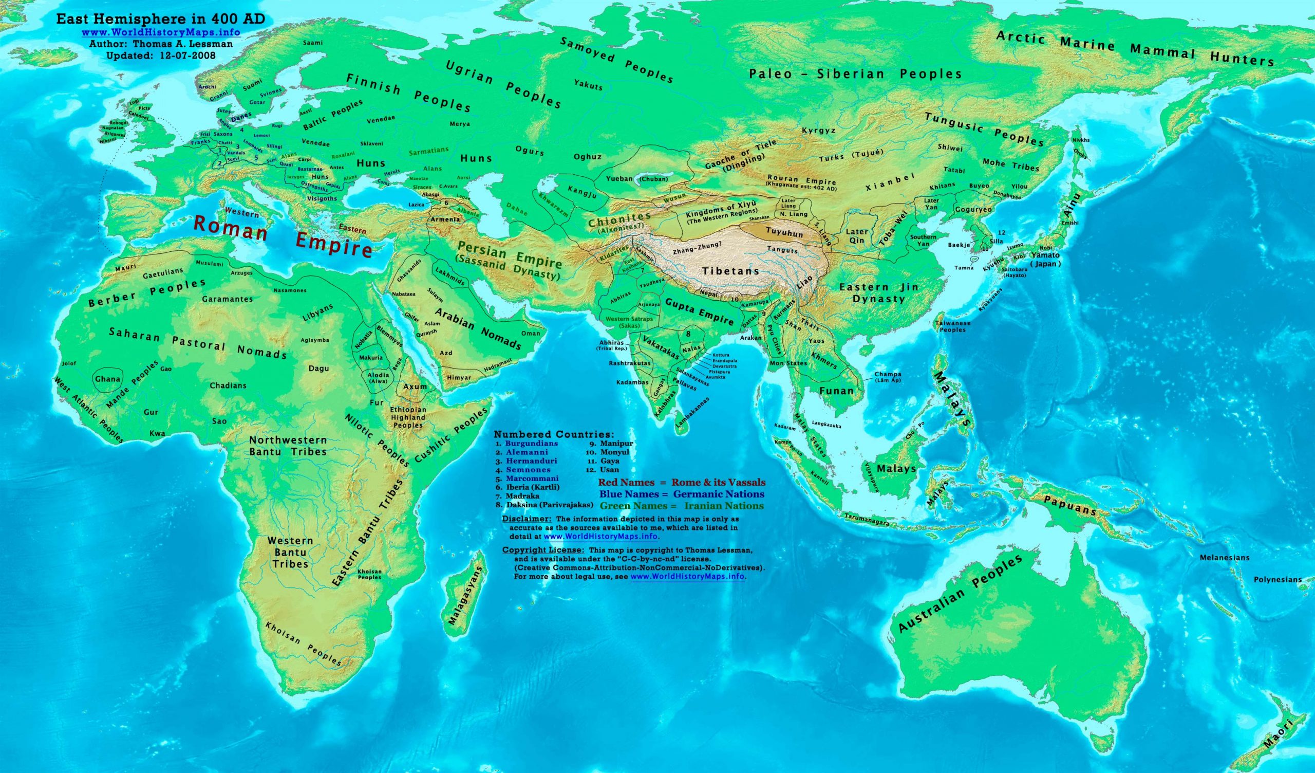
https://www.worldhistorymaps.info/wp-content/uploads/2021/03/map-400ad.jpg
Primary Sources for East-Hem_400ad.jpg:
- The DK Atlas of World History, 2000 Edition. (See specific references below).
- John Nelson. Interactive Historical Atlas of the World. Map of the “Countries of the World 1/1/400 CE.”
World History Maps Inc., Alexandria, VA, 2008. Available at www.WorldHistoryMaps.com.
- Euratlas. Periodical Historical Atlas of Europe. Map of “Europe in 400 AD”.
- User:Javierfv1212. Map of the “World_Map_400_CE.PNG”. Available on Wikipedia.
- Bruce Gordon. Regnal Chronologies.
I – African information
* African Tribal locations are derived from:
- The DK Atlas of World History. Map of “Development of Complex Societies in Africa”. Pg 160.
(Bantus, Berbers, Chadians, Cushites, Garamantes, Gur, Khoisans, Mandes, Nilotics, West Atlantic Peoples, etc.)
- User:Javierfv1212. Map of the “World_Map_400_CE.PNG”. Available on Wikipedia.
II – Asian Information
* Arabian Tribal locations are derived from:
- MidEastWeb.org. Map of “5th Century Arabia”.
* Caucasian borders ( Albania , Colchis , Iberia , Lazica, and Persarmenia)
- Euratlas. Periodical Historical Atlas of Europe. Map of “Europe in 400 AD”.
* Chinese (Eastern Jin Dynasty) borders:
- Albert Herrmann, Ph.D. History & Commercial Atlas of China. Map of “16 States & Eastern Jin, 317-420 AD”.
- The DK Atlas of World History. Map of “The Later 16 Kingdoms period, c. 400 CE”. (Pg 261).
- John Nelson. Interactive Historical Atlas of the World. Map of the “Countries of the World 1/1/400 CE.”
* Greater India (Including modern Bangladesh, India, and Pakistan):
- John Nelson. Interactive Historical Atlas of the World. Map of the “Countries of the World 1/1/400 CE.”
- Joseph Schwartzberg.The Historical Atlas of South Asia. Map of “The Satavahana-Saka-Kushana Age 1-300ad”.
- The Xenophile Historian. A Concise History of India. Chapter 2 – The Classical Age of Indian Civilization.
- SA Ebisa. The World: Grand Atlas of History. Map of “Gupta Expansion”. On Mapas Imperialas (Spanish).
* Japanese Islands information:
- The DK Atlas of World History, 2000 Edition. Map of “State Formation in Korea & Japan to 650 CE”. Pg 264.
* Kidarite, East Kushan, and Kushansha borders are from:
- John Nelson. Interactive Historical Atlas of the World. Map of the “Countries of the World 1/1/400 CE.”
Note: These maps show Kidarites as ” Gandhara” and East Kushans as “Takasila” (Taxila).
- Joseph Schwartzberg.The Historical Atlas of South Asia. Map of “The Satavahana-Saka-Kushana Age 1-300ad”.
* Korean & Manchurian information derives from:
- Park Hyeon. Map of “History of Korea-375”. Available on Wikipedia.
- Albert Herrmann, Ph.D. History & Commercial Atlas of China. Map of “16 States & Eastern Jin, 317-420 AD”. * Malay Kingdoms & Peoples information is from:
- DK Atlas of World History, 2000 Ed. Map of “Areas influenced by India to 650 CE”. Pg 241.
* Persian Empire (Sassanid Dynasty) borders are derived from:
- Eastern borders: John Nelson. Interactive Historical Atlas of the World. “Countries of the World 1/1/400 CE.”
- Western borders: Euratlas.Periodical Historical Atlas of Europe. Map of “Europe in 400 AD”.
* Rouran/Juan-Juan information is from:
- Albert Herrmann, Ph.D. History & Commercial Atlas of China. Map of “Asia in 440 AD”.
Note: My map shows the Rouran’s approximate location 2 years before they founded the Khaganate (402 AD).
* Southeast Asia: (Funan, Lâm Áp/Linyi, Malay Kingdoms, Pyu Cities, Srivijaya, etc.)
- Joseph Schwartzberg.The Historical Atlas of South Asia. Map of “SE Asia to AD 650”. Pg 30.
- The DK Atlas of World History, 2000 edition. Map of ” Southeast Asia to 650 CE”. Pg 241.
- User:L_joo. Map of Funan. Available on Wikipedia.
* Xionite (White Huns) are derived from:
- John Nelson. Interactive Historical Atlas of the World. Map of the “Countries of the World 1/1/400 CE.”
- Albert Herrmann, Ph.D. History & Commercial Atlas of China. Map of “Asia in 440 AD”.
III – European Information
* European information is derived from:
- Euratlas. Periodical Historical Atlas of Europe. Map of “Europe in 400 AD”.
- Denis Bellemare. Historical Atlas of Late Antiquity. Comparrison of: a – Maps of “West Europe in 380 AD” and “East Europe in 380 AD”. b – Maps of “West Europe in 420 AD” and “East Europe in 420 AD”.
IV – Australia, Siberia, & Other Fringe Areas
Note: Fringe information is derived from comparisons of these sources:
- The DK Atlas of World History. Comparison of
a – “The World in 250 CE”, pg 46 & “The World in 500 CE” pg 50.
- User:Javierfv1212. Map of the “World_Map_400_CE.PNG”. Available on Wikipedia.
Note: Much of the information in this map was cross-checked with Bruce Gordon’s Regnal Chronologies.
Roman Empire
January 9 – Emperor Arcadius gives his wife Aelia Eudoxia the official title of Augusta. She is able to wear the purple paludamentum and is depicted in Roman currency.
Anthemius, praetorian prefect of the East, is sent on an embassy to the Persian capital, Ctesiphon, to congratulate King Yazdegerd I on his accession the year before.
A riot breaks out in Constantinople; the Great Palace is burned to the ground. Gainas, a Gothic leader, attempts to evacuate his soldiers out of the city, but 7,000 armed Goths are trapped and killed by order of Arcadius. After the massacre, Gainas tries to escape across the Hellespont, but his rag-tag ad hoc fleet is destroyed by Fravitta, a Gothic chieftain in imperial service.
Winter – Gainas leads the remaining Goths back to their homeland across the Danube. They meet the Huns and are defeated; the Hunnic chieftain Uldin sends the head of Gainas to Constantinople, where Arcadius receives it as a diplomatic gift.
Europe
The Franks establish themselves in the North of the Netherlands.
The Paeonians (Illyricum) lose their identity (approximate date).
The Vandals start their westward trek from Dacia and Hungary.
Asia
Chrysanthemums are introduced into Japan (approximate date).
Richū, the eldest son of Nintoku, becomes the 17th Emperor of Japan.
Source: Wikipedia