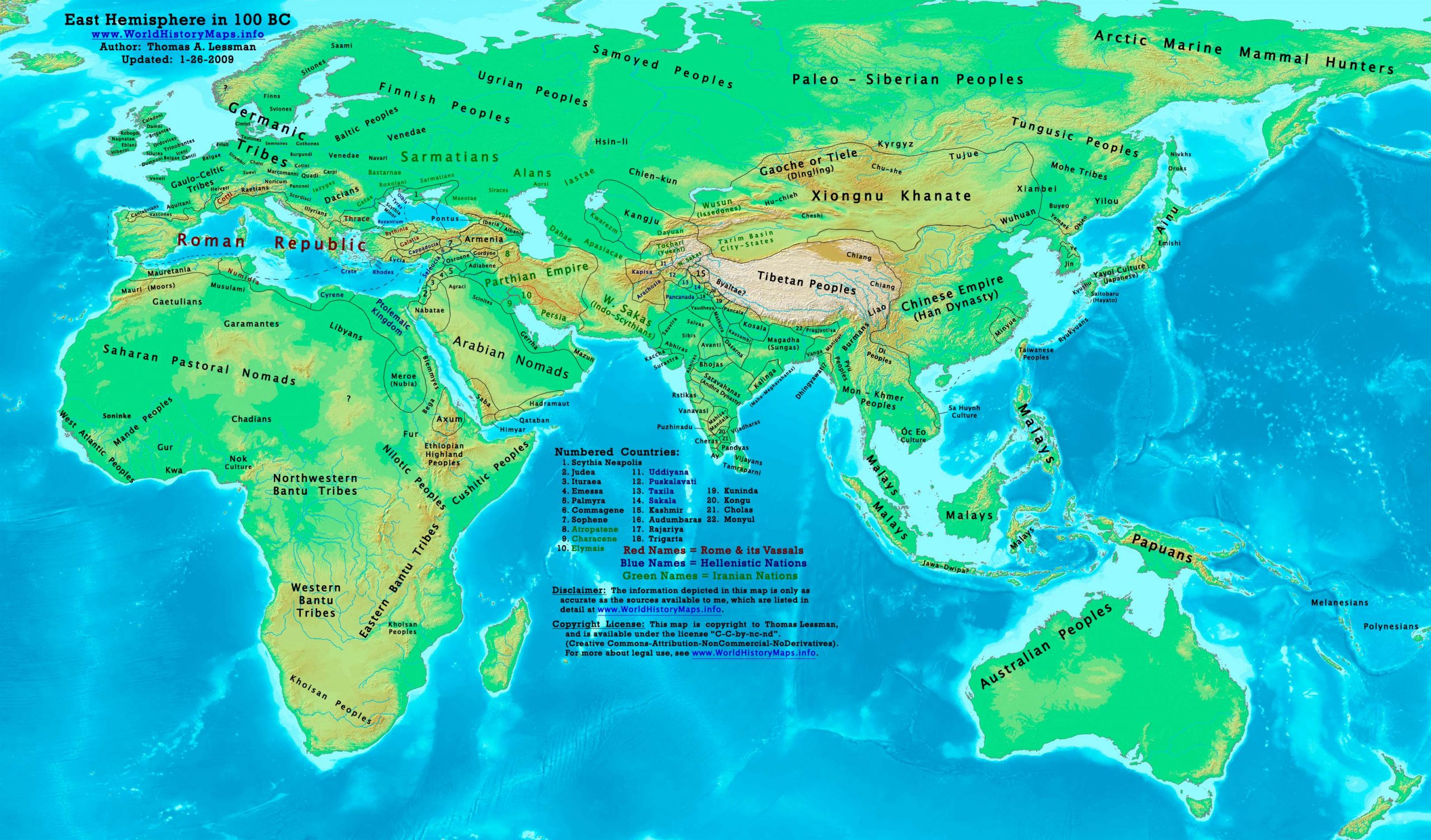
https://www.worldhistorymaps.info/wp-content/uploads/2021/03/map-100bc.jpg
Primary Sources for East-Hem_100bc.jpg:
- The DK Atlas of World History, 2000 edition. (See specific map refs below).
- John Nelson. Interactive Historical Atlas of the World since 500BCE. Map of “Countries of the World 1/1/100 BCE.”
World History Maps Inc., Alexandria, VA, 2008. Available at www.WorldHistoryMaps.com.
- Albert Herrmann, Ph.D. History & Commercial Atlas of China. Map of “Hsiung-nu in Central Asia, 128-36 BC”.
Harvard University Press, 1935. Available at http://huhai.net.
- Joseph Schwartzberg. Historical Atlas of South Asia. Oxford University Press, 1992.
Part of the Digital South Asia Library.
- User:Javierfv1212. Map of the “World_in_100_BCE.PNG”. Available on Wikipedia.
I – African information
* North Africa borders and tribal locations are from:
- 1. John Nelson. Interactive Historical Atlas of the World. Map of “Countries of the World 1/1/100 BCE.”
- The DK Atlas of World History. Map of “Development of Complex Societies in Africa”. Pg 160.
(Bantus, Berbers, Chadians, Cushites, Garamantes, Gur, Khoisans, Mandes, Nilotics, West Atlantic Peoples, etc.)
* Ptolemaic Kingdom borders are from:
- The DK Atlas of World History, 2000 edition. Map of “Alexander’s Successors”. Pg 224.
- John Nelson. Interactive Historical Atlas of the World. Map of “Countries of the World 1/1/100 BCE.”
* Sub-Saharan Africa tribal locations are from:
- The DK Atlas of World History, 2000 edition. Map of “Development of Complex Societies in Africa”. Pg 160.
(Bantus, Berbers, Chadians, Cushites, Garamantes, Gur, Khoisans, Mandes, Nilotics, West Atlantic Peoples, etc.)
II – Asian Information
* Chinese Empire (Han Dynasty):
- Albert Herrmann, PhD. History & Commercial Atlas of China. Map of “Hsiung-nu in Central Asia, 128-36 BC”.
- John Nelson. Interactive Historical Atlas of the World. Map of “Countries of the World 1/1/100 BCE.”
- The DK Atlas of World History, 2000 edition. Map of “The Han Empire”. Pg 260.
* Greater India (Including modern Bangladesh, India, and Pakistan):
Indo-Greek Kingdoms
- Joseph Schwartzberg.The Historical Atlas of South Asia. Map of “Probable migrations to South Asia (200-1BC)”.
- John Nelson. Interactive Historical Atlas of the World. Map of “Countries of the World 1/1/100 BCE.”
- South Asia Coin Group (SACG). Map of “Major Powers of Post-Mauryan India”.
- User:PHGCOM. Map of “Campaigns of the Indo-Greeks”. Available on Wikipedia.
- User:Javierfv1212. Map of the “World_in_100_BCE.PNG”. Available on Wikipedia.
- Rama Shankar Tripathi.History of Ancient India. Pgs 202-211.
- Encyclopaedia Iranica. Article on Bactria. (section on Hellenistic Bactria).
- Encyclopaedia Iranica. Article on the Indo-Greek Dynasties.
Mahameghavahana Dynasty
- Joseph Schwartzberg. The Historical Atlas of South Asia. Map of “The Satavahana-Saka-Kushana Age 1-300ad”.
- John Nelson.Interactive Historical Atlas of the World. Map of “Countries of the World 1/1/100 BCE.”
- User:Javierfv1212. Map of the “World_in_100_BCE.PNG”. Available on Wikipedia.
Satavahana Dynasty
- Joseph Schwartzberg.The Historical Atlas of South Asia. Map of “Probable migrations to South Asia (200-1BC)”.
Sunga Dynasty
- Joseph Schwartzberg.The Historical Atlas of South Asia. Map of “Probable migrations to South Asia (200-1BC)”.
- John Nelson. Interactive Historical Atlas of the World. Map of “Countries of the World 1/1/100 BCE.”
* Judea borders are derived from:
- John Nelson.Interactive Historical Atlas of the World. Map of “Countries of the World 1/1/100 BCE.”
- Livius.org. Map of “Israeli Borders, 167-76 BC”.
- Wikipedia. Article about the Hasmonean Kingdom,
- Armenica.org. Map of the “Armenian Empire, 95-66 BC” under Tigranes the Great.
* Kangju is derived from:
- Albert Herrmann, PhD. History & Commercial Atlas of China. Map of “Han Economic Development, c.100BC ”.
* Korea (Jin) borders are from:
- Albert Herrmann, PhD. History & Commercial Atlas of China. Map of “Han Economic Development, c.100BC ”.
- John Nelson.Interactive Historical Atlas of the World. Map of “Countries of the World 1/1/100 BCE.”
- Note: Different Korean borders are shown in:
* Park Hyeon. Map of “History_of_Korea-108BC”. Available on Wikipedia.
* Min-Yue borders are derived from:
- John Nelson.Interactive Historical Atlas of the World. Map of “Countries of the World 1/1/100 BCE.”
* Palmyra borders are derived from a combination of:
- User:Javierfv1212. Map of the “World_in_100_BCE.PNG”.
- Wikipedia. Article about Palmyra.
* Parthian Empire borders are derived from:
- John Nelson.Interactive Historical Atlas of the World. Map of “Countries of the World 1/1/100 BCE.”
* Sakastan borders come from:
- User:PHGCOM. Map of “Sakastan in 100 BC”. Available on Wikipedia’s article about Sakastan.
* Steppe Tribes (Chien-kun, Chu-she, Chu-shih, Dingling, Donghu, Hu-chieh, etc.) are from:
- Albert Herrmann, PhD. History & Commercial Atlas of China. Map of “Hsiung-nu in Central Asia, 128-36 BC”.
* Syrian borders (Seleucids, Palmyra, Osroene, Adiabene, etc.) are derived from:
- John Nelson.Interactive Historical Atlas of the World. Map of “Countries of the World 1/1/100 BCE.”
- Armenica.org. Map of the “Armenian Empire, 95-66 BC” under Tigranes the Great.
* Note: Seleucid rule over the “spur” of land west of Judea is derived from
- William R. Shepherd. Map of “The Growth of Roman Power in Asia (Asia Minor II)”.
* Xiongnu/Hsiung-nu Khanate:
- Albert Herrmann, PhD. History & Commercial Atlas of China. Map of “Hsiung-nu in Central Asia, 128-36 BC”.
- John Nelson.Interactive Historical Atlas of the World. Map of “Countries of the World 1/1/100 BCE.”
III – European Information
* Celtic Tribes and locations are derived from:
- Wikipedia. Articles about the various tribes depicted.
* Germanic Peoples location is derived from:
- Wikipedia. Article about the Germanic Peoples.
* Roman Empire is well documented. Here are some of the better sources I used:
- The DK Atlas of World History, 2000 edition. Map of “Roman Conquests to 120 BC” (pg 179).
- John Nelson. Interactive Historical Atlas of the World. Map of the “Countries of the World 1/1/100 BCE.”
- User:Varana. Map of the “Phases of the Roman Empire”. Available on Wikipedia.
Note: Much of the information in this map was cross-checked with Bruce Gordon’s Regnal Chronologies.
Roman Republic
Consuls: Lucius Valerius Flaccus, Gaius Marius (Marius’s sixth consulship).
Manius Aquillius celebrates an ovation for victories in the Second Servile War.
Lucius Appuleius Saturninus, a tribune, passes a law to redistribute land to military veterans. The law requires that all senators swear to abide by it. Quintus Caecilus Metellus Numidicus refuses and is exiled. He goes to Rhodes to study philosophy.
Late summer–autumn: Saturninus stands for tribune again for the following year, and is elected. His associate, the praetor Gaius Servilius Glaucia, attempts to stand for the consulship (illegally, as praetors cannot immediately become consul). A rival candidate, Gaius Memmius, is found murdered by agents of Saturninus and Glaucia, who are declared public enemies by the Senate. The Senate issues the senatus consultum ultimum, and Marius, as consul, defeats his former ally in battle in the Forum. Saturninus and his followers surrender on condition that their lives are spared, but they are stoned to death with roof tiles in the Curia Hostilia by renegade senators.
The building of the Sanctuary of Fortuna Primigenia, Palestrina, Italy, is begun. The model of it is now kept at the Museo Archeologico Nazionale, Italy (approximate date).
Asia Minor
Tigranes II of Armenia is placed on the Armenian throne by the Parthians in exchange for the cession of “seventy valleys”. (approximate date)
Source: Wikipedia