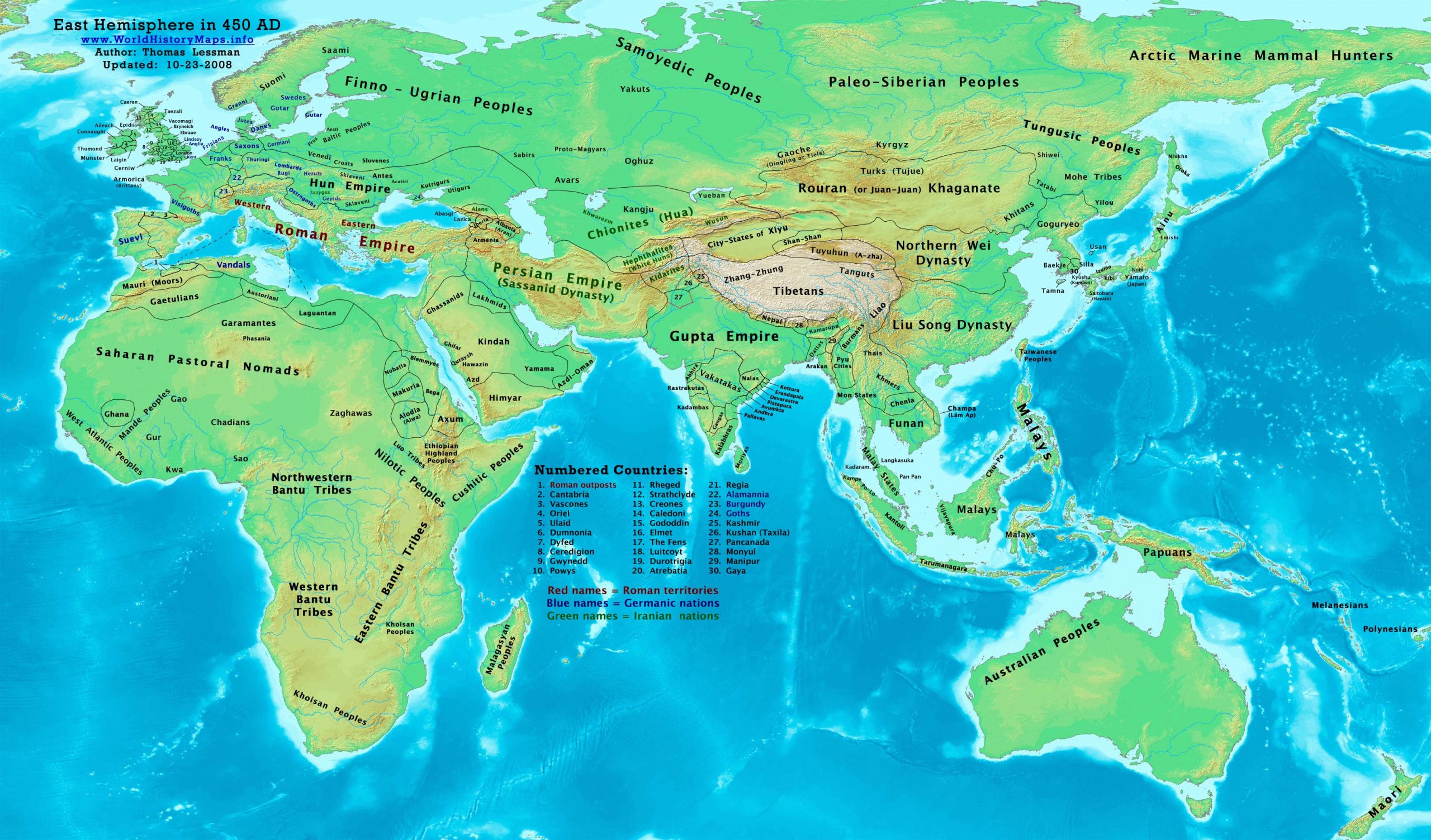
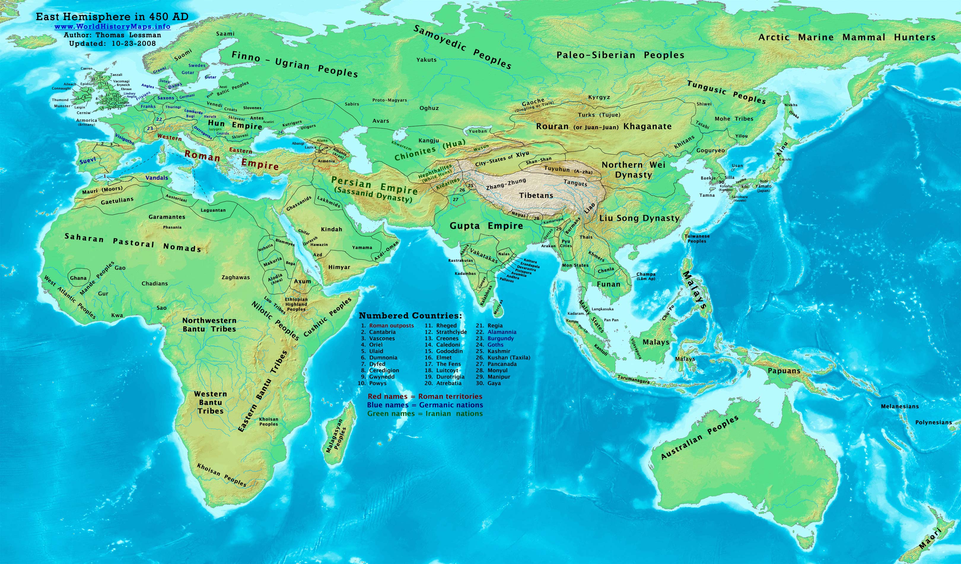
https://www.worldhistorymaps.info/wp-content/uploads/2021/03/map-450ad.jpg
Primary Sources for East-Hem_450ad.jpg:
- The DK Atlas of World History, 2000 edition. (See specific references below)
- John Nelson. Interactive Historical Atlas of the World. Map of the “Countries of the World 1/1/400 CE.”
World History Maps Inc., Alexandria, VA, 2008. Available at www.WorldHistoryMaps.com.
- Denis Bellemare. Historical Atlas of Late Antiquity. See specific references below.
- Albert Herrmann, Ph.D. History & Commercial Atlas of China. Map of “Asia in 440 AD”.
I – African information:
* African Tribal locations are derived from:
- The DK Atlas of World History. Map of “Development of Complex Societies in Africa”. Pg 160.
(Bantus, Berbers, Chadians, Cushites, Garamantes, Gur, Khoisans, Mandes, Nilotics, West Atlantic Peoples, etc.)
- User:Javierfv1212. Map of the “The world in 500 CE.PNG”. Available on Wikipedia
* North African borders are derived mostly from:
- Denis Bellemare. Historical Atlas of Late Antiquity. Maps of “NW Africa in 460 AD” and “NE Africa in 460 AD”.
II – Asian information:
* Greater India (Including modern Bangladesh, India, and Pakistan):
- John Nelson. Interactive Historical Atlas of the World. Map of the “Countries of the World 1/1/450 CE.”
- Joseph Schwartzberg. The Historical Atlas of South Asia. Map of “The Gupta-Vakataka Age, c. A.D. 300-500“
* Hephthalite & Hua borders are derived from a combination of:
- Albert Herrmann, Ph.D. History & Commercial Atlas of China. Map of “Asia in 440 AD”.
- John Nelson. Interactive Historical Atlas of the World. Map of the “Countries of the World 1/1/450 CE”.
* Japanese Islands :
- The DK Atlas of World History. Map of “State Formation in Korea & Japan to 650 CE”. Pg 264.
* Korean & Manchurian information:
- Park Hyeon. Map of “History_of_Korea_300_BC.png”. Available on Wikipedia.
* Persian Empire (Sassanid Dynasty) borders are from:
- John Nelson. Interactive Historical Atlas of the World. Map of the “Countries of the World 1/1/450 CE.”
- Albert Herrmann, Ph.D. History & Commercial Atlas of China. Map of “Asia in 440 AD”.
* Rouran/Juan-Juan borders are derived from:
- Albert Herrmann, Ph.D. History & Commercial Atlas of China. Map of “Asia in 440 AD”.
- John Nelson. Interactive Historical Atlas of the World. Map of the “Countries of the World 1/1/450 CE”.
III – European information:
* British Isles information is from:
- David Nash Ford. Early British Kingdoms. Map of “Britain in 450 AD”.
* European borders are derived from a comparrison to these maps:
- Denis Bellemare. Historical Atlas of Late Antiquity. Comparrison of: a – Maps of “West Europe in 420 AD” and “East Europe in 420 AD”, with b – Maps of “West Europe in 460 AD” and “East Europe in 460 AD”.
* Hun Empire borders are derived from these sources:
- Denis Bellemare. Historical Atlas of Late Antiquity. Compared combination of: a – Maps of “West Europe in 420 AD” and “East Europe in 420 AD”.
b – Maps of “West Europe in 460 AD” and “East Europe in 460 AD”.
- John Nelson. Interactive Historical Atlas of the World. Map of the “Countries of the World 1/1/450 CE.” 3. The DK Atlas of World History. 2000 Edition. Map of the “World in 500 CE”. Pgs. 54-54.
Note: Much of the information in this map was cross-checked with Bruce Gordon’s Regnal Chronologies.
Roman Empire
Spring – Justa Grata Honoria, eldest sister of emperor Valentinian III, sends her ring to Attila the Hun in an effort to escape a marriage being forced upon her by her brother. Now about 34, she has had an affair with an officer in her household and has allegedly plotted to overthrow Valentinian, who has sent her to a convent at Constantinople. Attila announces his intention to marry her, says he expects to be given half the Western Roman Empire as her dowry, and gathers a large Hun invasion force. Flavius Aetius, Roman general (magister militum), musters in Gaul an army of Burgundians, Celts, Ripuarians, Salian Franks and Visigoths under the command of the Visigoth king Theodoric I.
July 28 – Emperor Theodosius II, age 49, falls from his horse while hunting at Constantinople and dies soon afterward. He reigned since 408, mostly under the domination of his Christian sister Pulcheria, who has been allowed to return to court (see 441).
August 25 – Pulcheria is forced to marry and co-rule the Eastern Roman Empire. She gives the imperial diadem to the Illyrian (or Thracian) officer and senator Marcian, age 58, and is crowned as empress in the Hippodrome at Constantinople, in a first religious coronation ceremony.
Marcian orders the execution (or assassination) of the unpopular court eunuch Chrysaphius. He discontinues the tribute payments to Attila.
All the Temples of Aphrodisias (City of Goddess Aphrodite) are demolished and its libraries burned down. The city is renamed Stauroupolis (City of the Cross).
Europe
Angles, Saxons and Jutes invade Britain, marking the beginning of the Old English period (approximate date).
Remodelling begins of the Dome of Baptistry of Neon, Ravenna (Italy) (approximate date).
Persia
King Yazdegerd II summons the leading Armenian nobles to the Persian capital Ctesiphon, pressuring them to cut their ties with the Western Church.[1]
Asia
Nalanda University (India) is founded (approximate date).
Source: Wikipedia